
Warning
This document is current with effect from the date shown on the cover page. As the International Mine Action Standards (IMAS) are subject to regular review and revision, users should consult the IMAS project website in order to verify its status at (http://www.mineactionstandards.org/, or through the UNMAS website at http://www.mineaction.org).
Copyright notice
This UN document is an International Mine Action Standard (IMAS) and is copyright protected by the UN. Neither this document, nor any extract from it, may be reproduced, stored or transmitted in any form, or by any means, for any other purpose without prior written permission from UNMAS, acting on behalf of the UN.
This document is not to be sold.
Director
United Nations Mine Action Service (IMAS)
1 United Nations Plaza
New York, NY 10017
USA
E-mail: mineaction@un.org
Telephone: +1 (212) 963 0691
Website: www.mineactionstandards.org
Foreword
Management practices and operational procedures for mine action are constantly evolving. Improvements are made, and changes are required, to enhance safety and productivity. Changes may come from the introduction of new technology, in response to a new explosive ordnance (EO) threat, and from field experience and lessons learned in other mine action projects and programmes. This experience and lessons learned should be shared in a timely manner.
Technical Notes for Mine Action (TNMAs) provide a forum to share experience and lessons learned by collecting, collating and publishing technical information on important, topical themes, particularly those relating to safety and productivity. TNMAs complement the broader issues and principles addressed in International Mine Action Standards (IMAS).
The preparation of TNMAs follows a rapid production and approval process. They draw on practical experience and publicly available information. Over time, some TNMAs may be “promoted” to become full IMAS standards, while others may be withdrawn if no longer relevant or if superseded by more up-to-date information.
TNMAs are neither legal documents nor IMAS. There is no legal requirement to accept the advice provided in a TNMA. They are purely advisory and are designed solely to supplement technical knowledge or to provide further guidance on the application of IMAS. TNMAs are published on the IMAS website at www.mineactionstandards.org.
Introduction
The release of land affected by explosive ordnance (EO) contamination is a core objective of mine action programmes. Land release enables communities to safely regain access to land and infrastructure while ensuring that contamination risks are appropriately managed.
The second edition of IMAS 07.11 Land Release, published in 2026, strengthens the evidence-based approach to land release and places greater emphasis on evidence-based decision-making, continuity across the land release process, and the importance of establishing nationally defined criteria to support consistent and transparent land release decisions. This TNMA provides guidance for implementing land release in accordance with IMAS 07.11 Land Release.
1. Scope
This TNMA provides guidance for implementing land release in accordance with IMAS 07.11 Land Release, with a particular focus on the assessment and application of evidence and criteria used to support land release decisions.
It is intended to assist national mine action authorities and implementing organizations in applying consistent, transparent, and effective land release decisions, particularly for cancellation and reduction of suspected or confirmed hazardous areas.
2. Normative references
A list of normative references is given in Annex A. Normative references are important documents to which reference is made in this technical note and which form part of the provisions of this technical note.
3. Terms and definitions
A complete glossary of all the terms, definitions and abbreviations used in the International Mine Action Standards (IMAS) series is given in IMAS 04.10.
In the IMAS series, the words “shall”, “should” and “may” are used to indicate the intended degree of compliance:
- “shall” is used to indicate requirements, methods or specifications that are to be applied in order to conform to the standard. This term is not used in TNMAs, as their contents are purely advisory.
- “should” is used to indicate preferred requirements, methods or specifications; and
- “may” is used to indicate a possible method or course of action.
3.1
all reasonable effort
minimum acceptable level of effort to identify and document contaminated areas or to remove the presence or suspicion of explosive ordnance
Note 1 to entry: All reasonable effort has been applied when the commitment of additional resources is considered to be unreasonable in relation to the results expected.
3.2
cancelled land
suspected or confirmed hazardous area concluded not to contain evidence of EO contamination, based on reliable information that meets established cancellation criteria
Note 1 to entry: Cancellation may occur at any stage of the land release process, when it is reasonably established that there is no evidence of EO contamination.
Note 2 to entry: Cancelled land is measured in square metres (m2).
3.3
cleared land
area where all specified EO hazards have been removed and/or destroyed to a specified clearance depth
Note 1 to entry: Cleared land is measured in square metres (m2).
3.4
confirmed hazardous area
CHA
area where the presence of contamination by explosive ordnance has been confirmed on the basis of direct evidence
3.5
direct evidence
verifiable information that confirms the presence of explosive ordnance with certainty
3.6
explosive ordnance
EO
interpreted as encompassing mine action’s response to the following munitions:
- mines;
- cluster munitions;
- unexploded ordnance;
- abandoned ordnance;
- booby traps;
- other devices (as defined by CCW APII);
- improvised explosive devices
Note 1 to entry: Improvised explosive devices (IEDs) meeting the definition of mines, booby traps, or other devices fall under the scope of mine action when their clearance is undertaken for humanitarian purposes and in areas where active hostilities have ceased.
3.7
explosive ordnance disposal spot task
EOD spot task
disposal of single or multiple explosive ordnance discovered outside a suspected or confirmed hazardous area
3.8
fade out
the gradual reduction of clearance activities in an area contaminated with EO as a result of achieving a prescribed distance from the last known EO without finding any other evidence of EO in that area.
3.9
indirect evidence
information that suggests the possible presence of explosive ordnance but does not confirm it with certainty
3.10
intrusive intervention
action involving the active investigation of the ground, structures, or objects in a suspected or confirmed hazardous area, undertaken to detect, confirm, or mark explosive ordnance hazards
Note 1 to entry: Intrusive intervention includes activities that disturb the ground or actively investigate the subsurface (such as ground-penetrating radar or other sensor technologies), followed by the analysis of the collected data to support evidence-based decision-making. It does not include the use of camera-equipped drones.
3.11
land release
process of applying all reasonable effort to identify, define, and remove all presence or suspicion of explosive ordnance through non-technical survey, technical survey, and/or clearance
Note 1 to entry: The criteria for “all reasonable effort” is defined by the national mine action authority.
3.12
mine action organization
MAO
organization (government, military, commercial, or non-governmental organization/civil society) responsible for implementing mine action projects or tasks
Note 1 to entry: The mine action organization may be a prime contractor, subcontractor, consultant, or agent.
3.13
national mine action authority
NMAA
government entity, often an inter-ministerial committee, in country affected by explosive ordnance, charged with the responsibility for broad strategic, policy and regulatory decisions related to mine action
Note 1 to entry: In the absence of an NMAA, it may be necessary and appropriate for the UN, or some other body, to assume some or all of the responsibilities of an NMAA.
3.14
non-technical survey
NTS
collection and analysis of data, without intrusive interventions, about the presence, type, distribution and surrounding environment of EO contamination, in order to define better where EO contamination is present, and where it is not, and to support land release prioritization and decision-making processes through the provision of evidence
3.15
reduced land
suspected or confirmed hazardous area concluded not to contain evidence of contamination by explosive ordnance, based on reliable information that meets established reduction criteria
Note 1 to entry: Reduction may occur at any stage during the land release process, when it is reasonably established that there is no evidence of contamination by explosive ordnance through the use of intrusive interventions.
Note 2 to entry: Reduced land is measured in square metres (m2).
3.16
residual contamination
<mine action> potential presence of explosive ordnance that may not have been identified or addressed after applying all reasonable effort in accordance with the land release process
3.17
residual risk
<mine action> risk that remains despite having applied all reasonable effort during the land release process
3.18
suspected hazardous area
SHA
area where there is reasonable suspicion of contamination by explosive ordnance on the basis of indirect evidence
3.19
technical survey
TS
collection and analysis of data, using appropriate intrusive interventions, about the presence, type, distribution and surrounding environment of EO contamination, in order to define better where EO contamination is present, and where it is not, and to support land release prioritisation and decision-making processes through the provision of evidence.
4. Planning for land release
4.1 Planning considerations
Planning for land release requires the establishment of criteria that are context-specific, reflect the principle of all reasonable effort, and are adaptable to varying types of evidence. These considerations should be documented in national mine action standards (NMAS) to ensure consistency and transparency in decision-making.
While flexibility is necessary to allow the application of professional judgement, decisions should always be supported and justified by evidence. Professional judgement should be exercised by competent personnel, supported by documented evidence, and applied in accordance with nationally established criteria. Decisions should always be supported and justified by evidence. Planning should be carried out at multiple levels, by the various actors involved, at the strategic and operational levels by NMAAs (sometimes also by regional or local authorities), and at the operational level by mine action operators. Operational planning can be carried out for large-scale geographic areas (that is, at the country level) for regions or areas, or down to the level of the individual task. An effective planning process requires an understanding of the nature of contamination, the impact of EO, the context in which mine action activities take place, the required resources, and established national and local priorities.
Land release is a non-linear, evidence-based process. Within a single land release task, the application of NTS, TS, and clearance may evolve in response to emerging evidence. The outcome of a land release activity (cancellation, reduction, or clearance) is determined by the evidence obtained and the nationally defined criteria, and not only by the initial activity type specified in the task order.
Accredited operators may switch between NTS, TS, and clearance methods within the same task when operational evidence justifies doing so, provided that:
- the organization is accredited for the activity performed;
- the rationale for the change is documented;
- quality assurance and quality control requirements are met;
- applicable NMAA approval processes are applied.
4.2 Gathering information
4.2.1 General
Information gathering is vital at all stages of a mine action programme to ensure that new hazards and changes to the operating context may be integrated and planning adjusted accordingly. It is even imperative at the outset of a mine action programme (when new institutions are established and new operators set up in a newly affected context) as it defines the framework that will guide and shape land release operations.
Incorrect and inadequate information may lead to higher risks for communities and operators during land release. It can also be difficult and costly to change and correct information once it is recorded in mine action information systems. Information gathering should therefore provide:
- an evidence-based indication of the size and scope of the problem (if any),including its socioeconomic impact;
- an assessment of the resources needed to meet the goals;
- the national capabilities and potential to address the problem; and
- an assessment of the need for external assistance (including financial, human skills, material, and information).
The information collected should be sufficient to enable a national authority to establish priorities and to begin setting out the framework for a national mine action programme and strategic and operational planning.
Mine action authorities and operators should make every effort to fully involve the mine-affected communities within the general information flow and management process. This can be done through the establishment of formal community-based reporting mechanisms (such as hotlines or training community representatives, platforms for engagements with local authorities, community liaison) and commitment to community involvement throughout the national mine action process. Inclusive community involvement taking into consideration sex, age, culture, among other diversity factors, improves both accuracy and trust in the land release process.
Once the initial structures are established and land release progresses, information generated through NTS, TS and clearance may yield evidence that refines knowledge of the nature and extent of contamination. Continuous updating of information supports adaptive planning and strengthens confidence in decision-making.
4.2.2 Country assessment
As soon as practical, the planning process should start with a formal assessment of the country’s situation. This assessment should draw heavily on existing information provided by former warring factions and from agencies and organizations familiar with the EO-affected countries or regions. Where UN assistance is requested, a multi-disciplinary assessment team may deploy to the country to validate and update existing information in the aftermath of renewed conflict. The country assessment should determine whether a national mine action programme is required. Full recognition should be given to ongoing work, including informal demining projects.
In order to develop the initial planning framework, the decision to implement comprehensive national survey efforts should be taken so that the magnitude of the problem, as well as prioritization and funding considerations, can be quantified. Key information requirements are outlined in IMAS 05.10 Information Management for Mine Action; however, they relate primarily to the nature, location, and extent of the EO contamination.
4.3 Long-term planning
Land release is a process that requires long-term commitment from national government entities, NMAAs, and other stakeholders. Long-term planning should be based on a structured, evidence-based approach that progressively reduces contamination while maximizing efficient use of available resources. NMAAs and mine action organizations should develop coherent strategies integrating NTS, TS, and clearance within a unified planning framework. Planning should be informed by reliable and recent data, including baseline information and ongoing survey outputs, to enable prioritization based on needs, socio-economic impact and national priorities.
Long-term planning should include:
- establishing coordination and cooperation mechanisms across state authorities involved in, or otherwise related to, issues of EO contamination;
- ensuring adequate resources are available to capture the full extent of contamination from as early as practicable;
- preparing and sharing evidence-based long-term plans with government stakeholders, donors, UN agencies, and implementing partners;
- integrating risk education programmes for the duration of land release activities;
- establishing processes to review, amend, and update NMAS as the programme evolves;
- ensuring that NMAA resourcing (human, equipment, and funding) remains sufficient and sustained throughout the implementation of the national land release strategy;
- building and maintaining a long-term national technical response capability to deal with subsequent residual contamination;
- continued assessment of possible residual contamination to ensure the establishment of an adequate residual-risk management strategy.
5. Considerations for national frameworks
5.1 Alignment with IMAS
National standards on land release need to contextualize, rather than replicate, IMAS text since IMAS use broad and generic language for global applicability. Effective development of NMAS on land release requires national authorities to interpret IMAS provisions and translate them into clear and practical requirements that support safe, efficient, and nationally appropriate land release processes. If IMAS are reproduced verbatim, NMAS risk:
- failing to reflect national legal frameworks, institutional arrangements, or operational responsibilities;
- creating inconsistencies or gaps where national interpretation and operational direction are required but not provided;
- including provisions that are not relevant to the national contamination context or operational environment;
- omitting nationally defined criteria and thresholds necessary for implementation, such as:
- clearance depth requirements for different contamination types or land use categories;
- criteria for cancellation, reduction, and clearance requirements;
- requirements for the use of direct and indirect evidence;
- minimum required documentation and reporting requirements;
- requirements for quality assurance and quality control activities;
- conditions for the use of specific methodologies or technologies, such as mechanical assets, remote sensing, or animal detection systems.
The NMAA should lead working groups comprising all stakeholders to draft and review NMAS, when needed.
5.2 Evidence requirements within NMAS
Land release decisions are based on evidence derived from multiple sources of information and supported by the application of all reasonable effort. When reviewing or updating NMAS, authorities should consider whether national standards clearly articulate how evidence is understood and applied in practice.
EXAMPLE: Authorities may compare the result of TS and clearance with the initial classification of hazardous areas to assess if the use of evidence for the identification of hazardous areas is efficient.
5.3 Documentation
Traceability is important in land release decisions. National standards should therefore consider whether appropriate documentation is available to support the land release process, including:
- standardized documentation provided by the tasking authority to the operator (task order, implementation plan, prioritization);
- survey recording;
- evidence assessment;
- handover documentation;
- any other documentation about the rationale for decision-making, including the information that supported decisions and who authorized them.
National standards should contain a comprehensive list of documentation on land release activities to be retained, together with defined retention periods. This facilitates the demonstration of compliance with land release requirements, supports quality assurance activities and the application of all reasonable effort.
6. Triangulation of information
Triangulation of information is the process of verifying findings through the systematic comparison of information from three independent sources, where available. The assessment should consider the relevance, reliability, and independence of the available information when determining the confidence that can be placed in the findings. It therefore relies on confidence in the information and reliability of the source. It takes place throughout all steps described in sections 7 and 8 and aims to increase the reliability of conclusions, reduce bias, and ensure evidence-based decision-making.
The triangulation process starts by clearly defining the key question or finding that needs verification. Relevant and independent sources are then identified (for example, community feedback, operational records, direct observation, or quantitative data). Information from these sources is compared to identify whether it converges, partially diverges, or contradicts itself.
When conducting triangulation, it is important to distinguish between independent and non-independent sources.
- Independent sources gather or produce information separately and can corroborate a finding without relying on the same origin.
EXAMPLE: CCTV footage, vehicle telematics, and independent witness statements supporting the same account of an incident.
- Non-independent sources originate from the same information. The key consideration is the number of independent lines of information, not simply the number of reports available.
EXAMPLE: Several news articles or witness reports based on a single person’s account are treated as a single source of information rather than multiple independent sources.
The consistency, independence, and reliability of sources should be considered collectively. Triangulation is intended to strengthen confidence in findings by comparing information from multiple sources and identifying areas of agreement, discrepancy, or uncertainty. The following considerations may assist in assessing the outcome of the triangulation process.
- If sources contradict each other, or if information is derived from only one source, additional verification should be undertaken before conclusions are drawn.
- Discrepancies should be analysed rather than ignored, as they may reflect differences in perspective, gender, location, timing, or access to information.
- Care should be taken to avoid common errors, including relying on multiple sources that originate from the same information, overlooking contradictory information, treating triangulation as a box-ticking exercise, failing to document how conclusions were reached, or drawing conclusions without sufficient independent information.
- The triangulation process should be documented, including the sources consulted, any discrepancies identified, and the rationale for the final assessment.
7. Evidence for decision-making
7.1 General
As per IMAS 07.11 Land Release, NMAAs establish criteria for the definition of SHAs and CHAs in national standards. Criteria should define how documented direct and indirect evidence is used to support the classification, reclassification, and release of SHAs and CHAs.
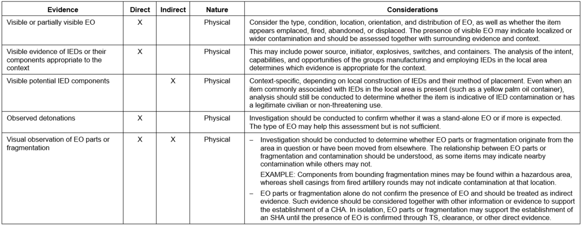
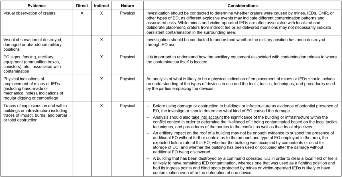
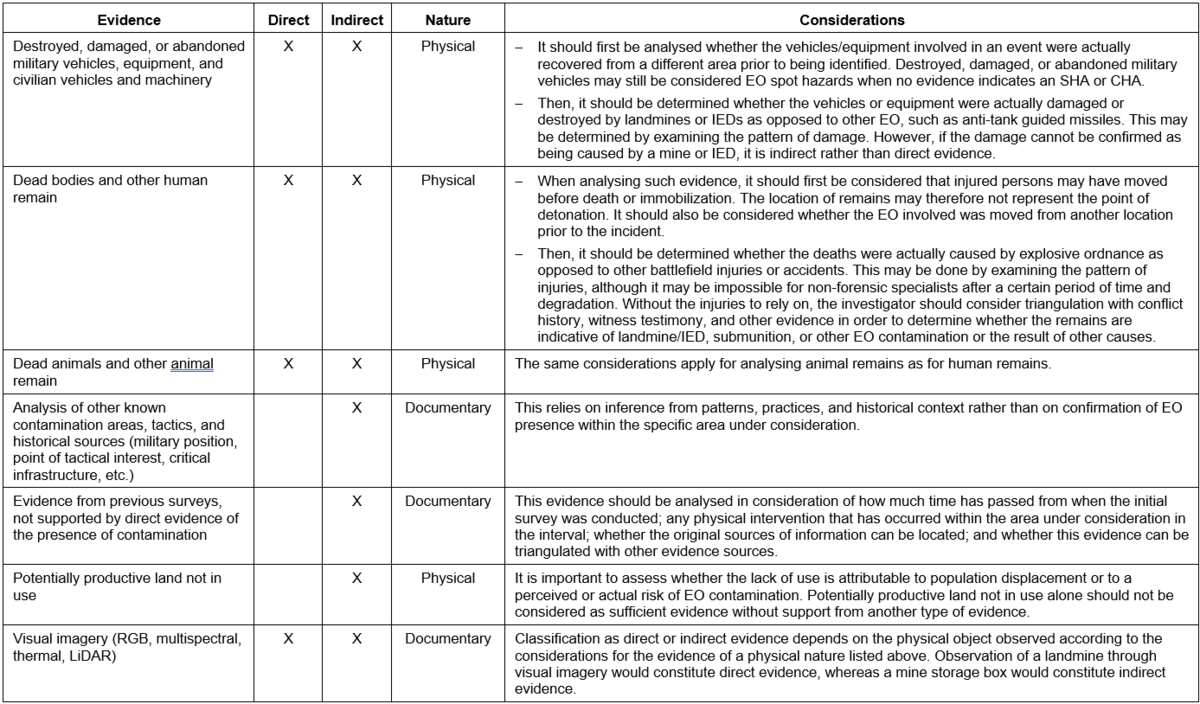
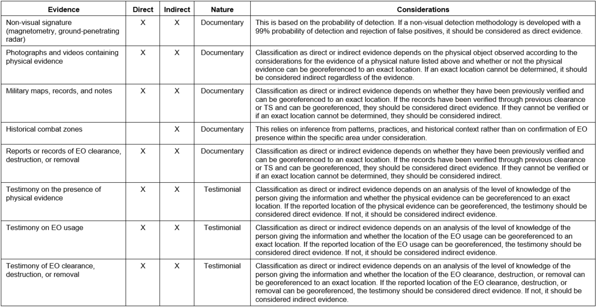
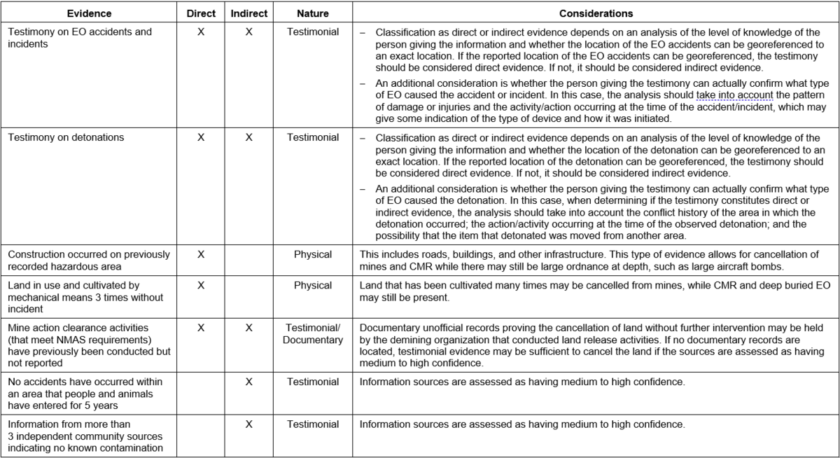
Annex B gives examples of evidence.
7.2 Collection of information
7.2.1 General
Evidence may be obtained from diverse sources of information at any time before and during the land release process. Activities that may generate evidence include, but are not limited to:
- analysis of open-source reporting showing past military operations in an area, EO accidents, or visible EO;
- analysis of documented findings of previous survey(s);
- analysis of satellite imagery containing visual signatures of EO or contextually significant associated features, such as military positions or trench systems;
- use of drones with various sensor systems (visual, thermal, multispectral, magnetic, etc.);
- physical observation (whether through the naked eye or through the use of visual enhancement or optical aids such as binoculars);
- interaction with witnesses;
- analysis of findings and observations generated through ongoing land release activities;
- analysis of information and evidence from adjacent areas.
The collected information is analysed, interpreted, and combined with deductive reasoning to generate findings and evidence. However, the method of collection alone does not determine whether the resulting evidence is direct or indirect. The reliability or type of technology used to collect the evidence affects the confidence assigned to it, but not its classification.
7.3 Categorization of information and evidence
Information and evidence used in land release should be systematically categorized to support transparent, consistent, and evidence-based decision-making. This helps clarify the strength of evidence, how it can be used, and the level of confidence that can be placed in it.
Categorization is not intended to be applied as a strict linear sequence. Depending on available information, and operational requirements, some steps may occur simultaneously, be repeated, or not be required in all cases.
Evidence in land release can be categorized based on its type (see 7.4) or its nature (see 7.5). In addition, the quality and strength of information can be assessed based on confidence in the information (classification of information) and reliability of the source (see 8).
Together, these considerations help determine the overall strength of evidence and its suitability for supporting land release decisions. Information and evidence should rarely be considered in isolation. Rather, multiple sources and types of evidence should be combined and analysed to build a coherent and defensible assessment.
7.4 Evidence type
As stated in IMAS 07.11 Land release, all collected evidence is categorized as either direct or indirect evidence (see 3.5 and 3.8). The process of identifying and analysing information sources, assessing the nature of the source, and evaluating source reliability and confidence in the information supports this categorization.
These evidence types determine whether the information is sufficient to confirm the presence of EO and establish a CHA, or whether it only indicates a suspicion of contamination and therefore supports the establishment of an SHA.
Annex B gives examples of evidence.
7.5 Nature of evidence
All evidence can be categorized and reported by their nature according to the following categories.
- Physical: Any tangible evidence that indicates the potential or confirmed presence of EO.
EXAMPLE: Visible EO, EO craters, mine signs, etc.
- Documentary: Recorded information that indicates the potential or confirmed presence of EO, including time-related and technology-derived evidence.
EXAMPLE: Maps, reports, datasets, etc.
- Testimonial: Information provided by witnesses indicating the potential or confirmed presence of EO, including behavioural and socio-economic indicators.
EXAMPLE: Land use patterns, avoidance, or changes in land use.
8. Confidence in information and reliability of sources of information
8.1 General
Confidence should reflect the quality of evidence and source reliability. The extent to which this can be demonstrated or established should determine whether the information collected or evidence is used in the land release decision-making process. Several methods may be used to assess and classify both the reliability of sources and the confidence in information.
8.2 Confidence in information
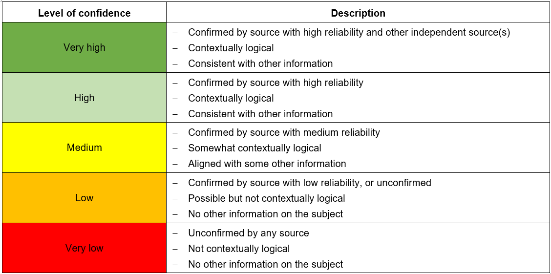
Confidence in information is the degree to which available information is considered accurate, consistent, and reliable for supporting land release decisions. It reflects an assessment of the internal coherence of the information, its alignment with known context, and the extent to which it is supported or contradicted by other available information. As a result, confidence in information may change as further information becomes available. Levels of confidence help determine how much weight is given to specific information when analysing evidence and ensure that decisions are based on a transparent and structured assessment of confidence. The confidence levels presented in Table 1 are intended to support evidence assessment and the application of professional judgement. Confidence levels should not be interpreted as prescriptive decision thresholds for land release (see Table 1).
Table 1 – Confidence in information
8.3 Source reliability
8.3.1 General
Source reliability is the degree of credibility or trust that is placed in the origin of information. It assesses how information was obtained and transmitted, recognizing that accuracy generally decreases as the distance from the original event increases, and as more time elapses since the information was originally received or recorded.
Source reliability may vary depending on the nature of the source, whether it is physical, documentary, or testimonial.
8.3.2 Physical evidence
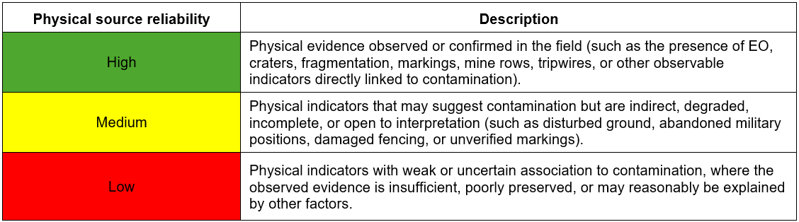
Physical evidence may originate from observable indicators identified in situ. Assessing source reliability helps determine the degree of confidence that can be placed in the physical evidence, particularly by considering how directly the observed indicators are associated with EO contamination and whether alternative explanations may exist (see Table 2).
Table 2 – Source reliability for physical evidence
8.3.3 Documentary evidence
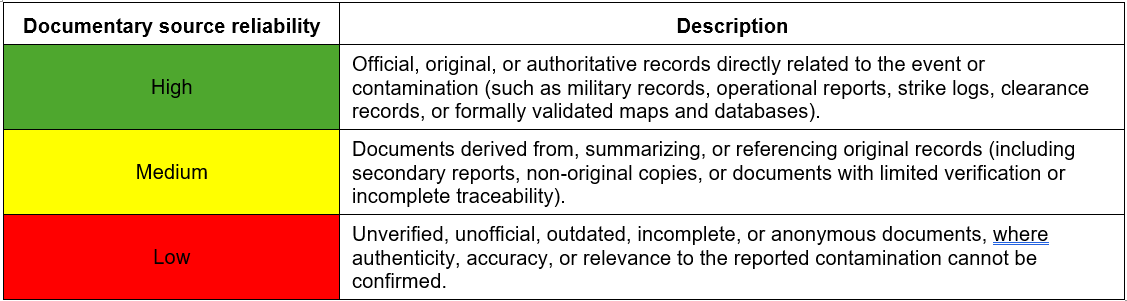
Documentary evidence may originate from records, reports, maps, databases, or other written or digital sources of information. Assessing source reliability helps determine the degree of confidence that can be placed in the document, particularly by considering its origin, authenticity, traceability, and proximity to the original event or reporting source (see Table 3).
Table 3 – Source reliability for documents
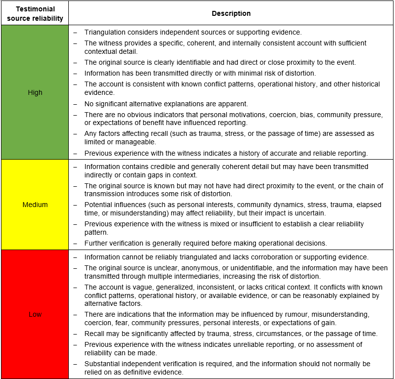
8.3.4 Testimonial evidence
Testimonial evidence is often a key component of NTS and land release decision-making. However, unlike documentary or physical evidence, it may be difficult to assess testimonial evidence objectively as it is often highly context dependent. Assessing the reliability of testimonial sources should determine the degree of confidence that can be placed in the information by considering both:
- the proximity of source / witness to the reported event or information source; and
- the reliability of source / witness.
Reliability of testimonial sources may be influenced by the methods used to collect information, including the skills and experience of the interviewer and their ability to facilitate objective and accurate information gathering. Therefore, appropriate training of personnel conducting interviews is extremely important, whether during NTS, TS, or community engagement activities. Where practical, training needs to take into account the competencies outlined in T&EP 08.10/01/2024, Competency standards for non-technical survey surveyor and non-technical survey team leader.
8.3.4.1 Proximity of the source
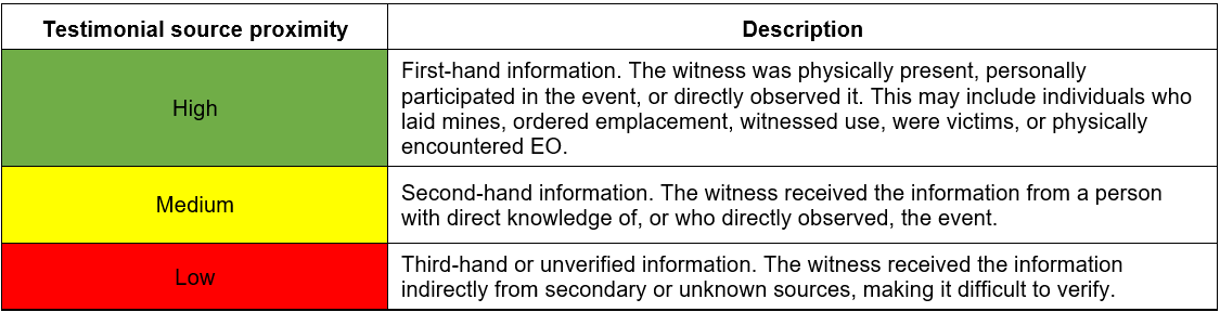
A crucial consideration is the source’s proximity to the event, which should be assessed separately from other factors that may influence reliability. For the purposes of NTS, source proximity for testimonials can be assigned an overall rating of high, medium, or low reliability based on the assessor’s judgement of the information as a whole. These ratings are intended to support a consistent and proportionate assessment of testimonial evidence and should be applied with consideration of the source, the circumstances in which the information was obtained, the extent of corroboration available, and any factors that may affect the accuracy or reliability of the account (see Table 4).
Table 4 – Source proximity for testimonials
8.3.4.2 Reliability of the source
Assessing source reliability, beyond the proximity factor, takes into account the quality, consistency, and credibility of the information. Consideration should be given to the source of the information, the circumstances in which it was obtained, and the extent to which it can be corroborated (see Table 5). Relevant factors may include:
- whether the information can be triangulated or corroborated by other sources;
- the specificity, coherence, and consistency of the account provided;
- the existence of supporting evidence;
- the identity and credibility of the original source;
- the accuracy with which the information has been transmitted;
- whether important context or detail may be missing;
- whether the account is consistent with known conflict patterns, operational history, or other available information;
- whether the information can reasonably be explained by alternative factors;
- whether further verification is required before making operational decisions;
- any factors that may influence reporting or recall, including trauma, stress, the passage of time, misunderstanding, coercion, community pressures, expectations of assistance or employment, personal interests, or other motivations;
- previous experience with the same witness or source, where available.
Table 5 – Source reliability for testimonials
9. Criteria for cancellation or reduction, and clearance requirements
9.1 General
Once evidence has been defined and EO has been classified, criteria for how that evidence is applied should be developed to guide decisions on cancellation and reduction.
Local contexts vary significantly and different conflicts result in different types and levels of EO contamination. Approaches suitable for one category of EO may be inefficient or unsafe if applied to another. Therefore, criteria should be appropriate to the type of contamination and ensure that the level of effort and method applied are proportionate to the risk.
NOTE: For land release purposes, contamination is typically categorized into landmines (disaggregated further by anti-personnel and anti-vehicle mines), cluster munition remnants (CMR), and other EO. IEDs may also be treated as a distinct category, reflecting their specific characteristics and associated risks. This categorization allows criteria and methodologies to be tailored to the nature of the hazard.
Criteria should also reflect the operational environment and intended land use following release. Factors such as population density, patterns of land use, and the potential consequences of failure should be considered as they are likely to differ between an urban setting and in a rural or low-use environment.
The criteria for the creation of SHAs and CHAs may differ from the criteria used for their release. For example, at the end of a conflict, an area may meet the criteria for classification as a SHA based on indirect evidence, such as lack of land use, the presence of craters, and proximity to a frontline. However, conditions may change over time and, if displaced populations return and land use resumes – such as repeated mechanical cultivation – this may contribute to evidence supporting reduction or cancellation.
Such reasoning is context-dependent and should be applied with caution. It may be more relevant in areas affected primarily by anti-personnel or anti-tank mines, where patterns of land use and ground disturbance can provide useful indications. However, it is not universally applicable. In areas contaminated by CMR or other EO, items may remain present and hazardous despite repeated land use or seasonal activity. These factors alone are therefore not sufficient to support release decisions, without further triangulation and use of multiple sources.
All evidence should be assessed in combination, taking into account the type of contamination, environmental conditions, and local context. No single indicator should be considered determinative in isolation.
9.2 Application in areas with multiple contamination types
Hazardous areas containing multiple categories of EO should be recorded accordingly to support the selection of appropriate land release methodologies.
Where various categories of EO overlap within the same hazardous area, the clearance methodology should be based on the category of contamination the presents the highest risk.
Where various categories of EO are identified in separate, non-overlapping parts of a hazardous area during TS or clearance, it is good practice to subdivide the area and record these subdivisions as separate hazardous areas in the national mine action database. This allows each area to be addressed using the most appropriate methodology.
EXAMPLE: Where a hazardous area is initially recorded as containing landmines, and TS identifies additional EO (for example, rockets) in a separate part of the area, the area may be recorded as two distinct hazards: a CHA containing landmines; and a hazardous area containing other EO only.
This approach supports the application of appropriate methods to each hazard and avoids unnecessary application of more demanding clearance requirements where they are not needed.
EXAMPLE: If a team conducts TS or clearance using manual mine clearance methodology on an area incorrectly assessed to contain landmines, but actually does not contains landmines but contain other EO, the progress may be slow, expensive and inefficient. If a team conducts BAC on an area incorrectly assessed to contain EO not including landmines (but actually contains landmines), the team may have a catastrophic accident.
9.3 Criteria for establishment of hazardous areas
The criteria on how to use direct and indirect evidence should be clearly defined to ensure that decisions on the establishment of hazardous areas are consistent across the mine action programme, and to avoid exaggerated hazardous areas. The principles of land release as described in IMAS 07.11, 4.2, should also be taken into account.
Additionally, mine action programmes should keep in mind the following evidence specific considerations:
- Evidence should not be used as criteria for creating an SHA or CHA until it has been analysed and verified to establish the highest possible level of confidence.
- A single indirect evidence point is often insufficient to confidently establish an SHA.
- Potentially productive land not in use should not be treated as a stand-alone piece of indirect evidence. Rather, it should be supported by an additional piece of indirect or direct evidence suggesting the presence of EO contamination.
- Evidence which cannot be confidently geolocated should always be treated as indirect evidence.
- Evidence, which is relevant for one type of explosive hazard, may not necessarily be relevant for a different type of EO.
EXAMPLE: In an area expected to be contaminated with landmines, craters may serve as direct evidence, whereas they may count as indirect evidence in areas suspected of being contaminated by CMR or other EO.
The establishment of hazardous areas is normally accomplished through an initial NTS or baseline survey, which may be augmented by other surveys conducted periodically throughout the life cycle of the mine action programme to develop new evidence which may impact classification of the land.
Table 6 provides examples of criteria that can be used to establish a hazardous area. Not all criteria are the same for every context.
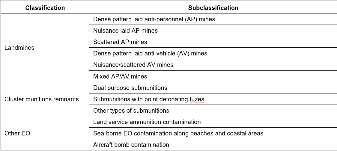
Once established, hazardous areas should be classified according to the EO contamination they are known or suspected to contain (landmines, CMR, and other EO). Where there are multiple classifications of EO within a hazardous area, all reasonable effort should be made to define the areas contaminated by each of the EO category through additional methods of evidence gathering. If this is not possible, the hazardous area should be classified according to the EO category that is the most restrictive, where land is more difficult to release.
If there is a need to break down these classifications into subclassifications in order to support prioritization and future land release criteria, the NMAA may do so. Table 7 shows an example of classification breakdown.
Table 6 – Criteria to support establishment of hazardous areas
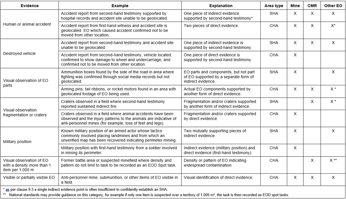
Table 7 – Example of classification breakdown
9.4 Cancellation criteria
Cancellation involves releasing land in SHAs or CHAs concluded to contain no evidence of EO contamination based on reliable information that meets the cancellation criteria established by the NMAA.
A previously recorded SHA or CHA may be partially or entirely cancelled after the initial NTS if the results of follow-on land release activities reveal new evidence that the NMAA’s cancellation criteria have been met (see Table 8).
NOTE: A finding of no evidence of EO contamination by follow-on land release activities does not satisfy the “new evidence” requirement for cancellation. The new evidence requirement is, for the most part, related to land/facility usage within the SHA/CHA after the initial NTS was completed without any EO accident/incident.
Cancellation may be conducted during any land release activity (NTS, TS and clearance) as long as the land meets the NMAA’s cancellation criteria. Land may be cancelled during TS or clearance without the need to deploy a dedicated NTS team. Technical survey and clearance team leaders and supervisors should be trained in accordance with T&EP 09.10/01/2023 to ensure compliance with the NMAA’s cancellation criteria.
Table 8 – Examples of cancellation criteria
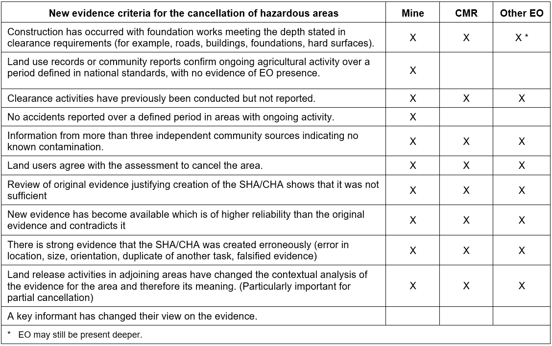
The examples presented in Table 8 are illustrative and should be assessed in combination with other relevant evidence, taking into account the type of contamination, the reliability of available information, and nationally established cancellation criteria. No single indicator should be treated as automatically sufficient to justify cancellation.
Figure 1 shows simplified examples of how NTS may support cancellation decisions in accordance with nationally defined criteria. The examples demonstrate that cancellation may apply to an entire hazardous area or only to part of it, depending on the evidence obtained and the outcome of follow-on land release activities. These examples are intended for illustrative purposes only and should be adapted to the operational context, contamination type, information management systems, national context, and applicable NMAS requirements.
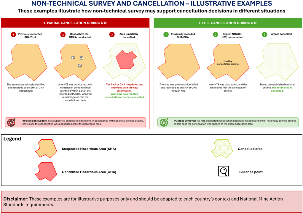
Figure 1 – Cancellation during non-technical survey
9.5 Reduction criteria
Reduction applies where TS and/or clearance have been conducted and evidence, or the lack thereof, supports releasing land based on established national reduction criteria. This may be achieved by:
- defining the land that requires clearance more accurately;
- confirming the area within a SHA/CHA that does not require clearance.
The examples and criteria in Table 9 are illustrative only and are intended to support NMAS development, rather than reproducing them directly.
Table 9 – Examples of reduction criteria
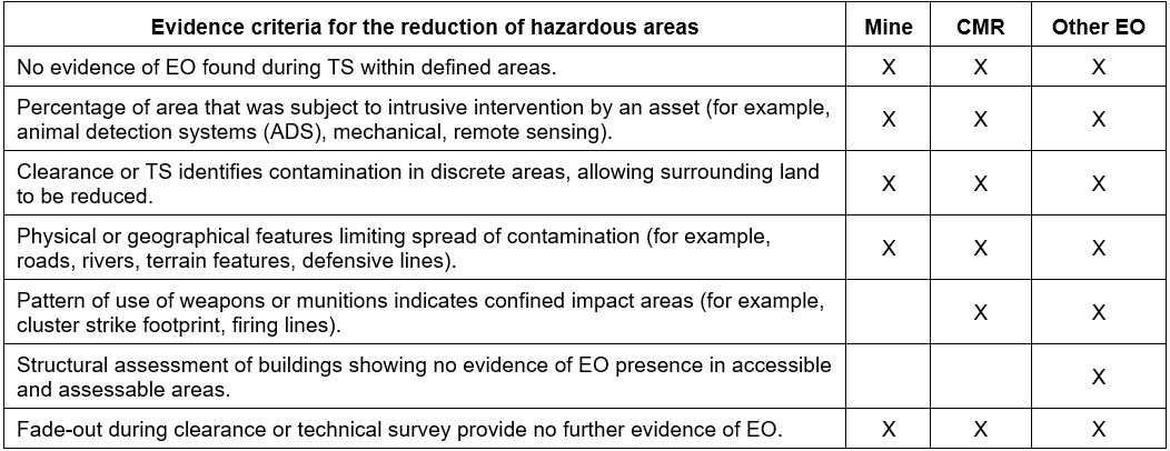
9.4 All reasonable effort to reduce land
The selection of TS methodology and the measurement of all reasonable effort should reflect the objective of the survey activity. Different approaches to TS may require different criteria for determining when sufficient confidence has been achieved to support reduction of land or the establishment of a CHA. The examples in Table 10 illustrate how follow-on activities may differ depending on whether TS is conducted systematically across an area or targeted toward identified points of interest.
Table 10 – Examples of follow-on activities during technical survey
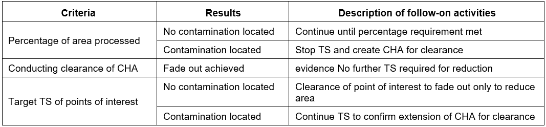
In NMAS, all reasonable effort related to reduction may, where appropriate, be demonstrated through the percentage of land that is processed (normally through TS) as one mean of supporting reduction decisions. The determination of all reasonable effort should remain evidence-based and should take into account the nature of the contamination, operational findings, and nationally established criteria, rather than relying solely on the percentage of land processed. This is one example of how all reasonable effort can be quantified. It is an effective method as long as consideration is given to whether or not contamination has been confirmed. Percentage-based TS criteria may be appropriate in situations where no evidence of contamination is identified. In such cases, systematic TS conducted over a defined proportion of the area may provide sufficient confidence to support reduction decisions where no contamination is found. Consideration should be given to the purpose of TS, which is to define and confirm the area that requires clearance. Where TS has successfully identified and delineated contaminated areas, additional survey only to achieve a predefined percentage of coverage may not represent an effective application of all reasonable effort.
The final land release product should accurately reflect the outcome of the land release process and the evidence obtained through TS and clearance activities. Land release records should distinguish between areas that required clearance and areas that were reduced based on the absence of evidence, ensuring transparency, traceability, and consistency in reporting. Figure 2 shows that the recorded land release product may differ depending on presence or absence of evidence identified during systematic TS.
When targeted TS is conducted, measuring all reasonable effort only through the percentage of area processed may not be appropriate. In targeted TS, the objective is to investigate identified areas of interest or hot spots derived from NTS information, direct evidence, conflict analysis, or known tactics and patterns of contamination.
Figure 3 shows that targeted TS may involve processing access lanes to identified evidence points and conducting investigation around each evidence point to a defined distance. If contamination is identified, a CHA is established. If no contamination is identified following completion of the intrusive investigation, the area may be reduced in accordance with national criteria.
Figure 4 provides simplified examples of how clearance activities may support clearance, reduction, or cancellation decisions based on evidence obtained during operations and nationally defined criteria. It emphasizes that as per IMAS 07.11 Land Release, land release is a non-linear process, and land may be cancelled or reduced at any stage when evidence indicates that no EO contamination is present.
Irrespective of the used approach, an implementation plan should identify and document all areas of interest requiring investigation, together with the methodology to be applied. The rationale for decision-making including the evidence considered, methodology applied, and justification for the final land release decision, should be clearly documented in completion records to support transparency, traceability, and future reassessment.
 All four figures used on this TNMA are examples, do not represent real minefield scenarios and are intended solely to illustrate possible approaches. They should not be interpreted prescriptively or applied strictly, but adapted to the specific context, available evidence, operational circumstances, and applicable national criteria.
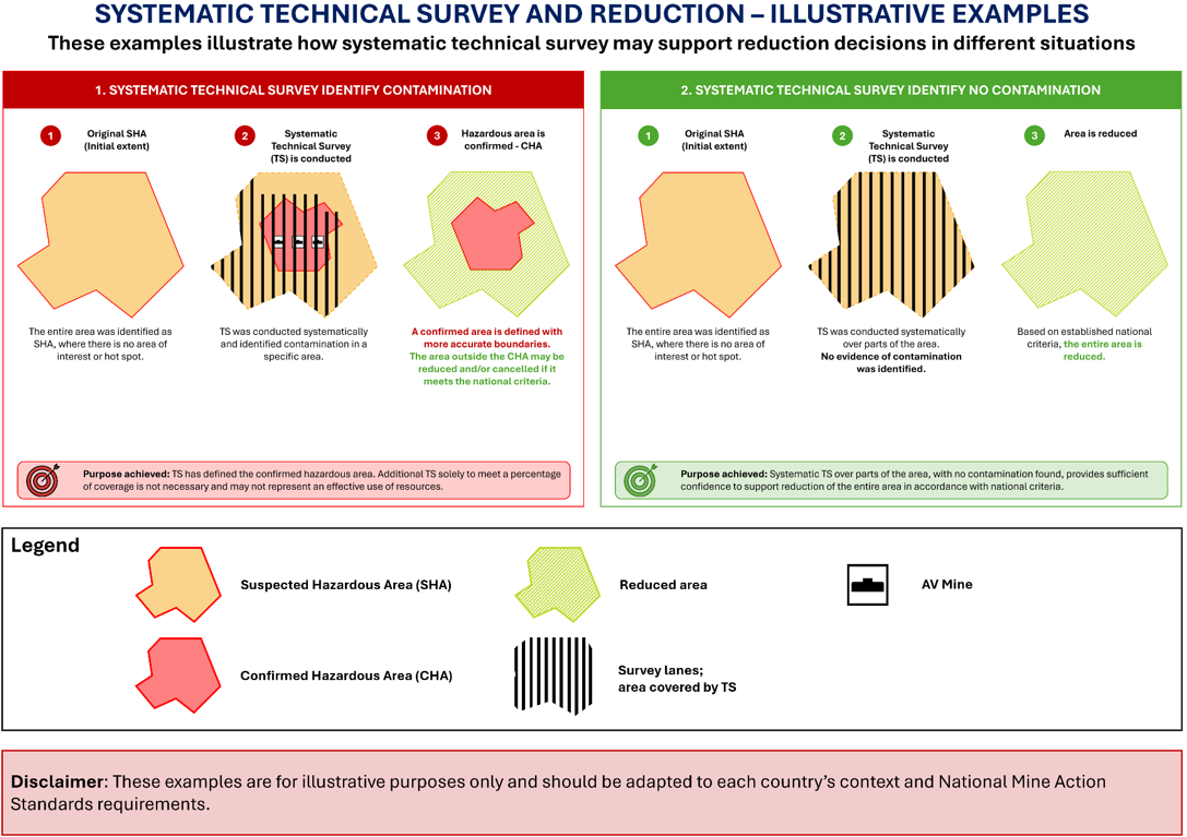
Figure 2 –Systematic technical survey supporting land release decisions
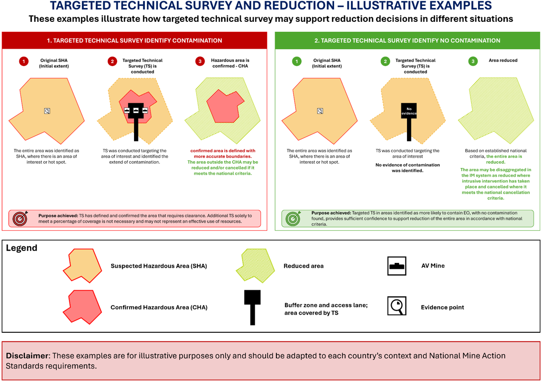
Figure 3 –Targeted technical survey supporting land release decisions
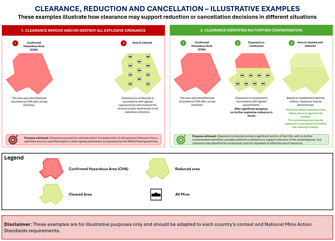
Figure 4 – Clearance in support of reduction and cancellation
9.7 Management of residual contamination
Managing residual contamination addresses both undetected EO that may remain present and the residual risk associated with such contamination (TNMA 07.14.01).
NMAAs and mine action organizations should ensure that national mine action frameworks include policies, responsibilities, and procedures for residual contamination management. This should include maintaining accurate records of released land; mechanisms to receive, record, and respond to evidence of EO; and the availability of appropriate response capacities.
Annex A (normative) References
The following documents contain provisions, which, through reference in this text, constitute provisions of this standard. For dated references, subsequent amendments to, or revisions of, any of these publications do not apply. However, parties to agreements based on this standard are encouraged to investigate the possibility of applying the most recent editions of the documents indicated below. For undated references, the latest edition of the normative document referred to applies.
- IMAS 04.10, Glossary of mine action terms, definitions and abbreviations
- IMAS 05.10, Information management for mine action
- IMAS 07.11, Land release
- TNMA 07.14/01, Residual risk management
- T&EP 08.10.01.2024, Competency standards for non-technical survey surveyor and non-technical survey team leader
- IMAS 09.10, Clearance requirements
- IMAS 09.11, Battle area clearance
- IMAS 09.13, Building clearance
The latest version/edition of these references should be used. The GICHD holds copies of all references used in this standard. A register of the latest version/edition of the IMAS standards, guides, and references is maintained by the GICHD, and may be read on the IMAS website (http://www.mineactionstandards.org/). National authorities, employers, and other interested bodies and organizations should obtain copies before commencing mine action programmes.
Annex B (informative) Evidence examples
Table B.1 is indicative only. Whether evidence is considered direct or indirect depends on the circumstances in which it is obtained and should be assessed based on the realities on the ground.
Table B.1 – Examples and classifications of direct and indirect evidence
Amendment record
Management of IMAS amendments
The IMAS series of standards are subject to formal review on a five-yearly basis. However, this does not preclude amendments being made within these five-year periods for reasons of operational safety and efficiency or for editorial purposes.
As amendments are made to this TNMA they are given a number. The date and general details of the amendment shown in the table below. The amendment is also shown on the cover page of the IMAS by the inclusion under the edition date of the phrase “incorporating amendment #.”
As the formal reviews of each IMAS are completed, new editions may be issued. In this case, amendments up to the date of the new edition are incorporated into the new edition and the amendment record table cleared. Recording of amendments then starts again until a further review is carried out.
The most recently amended IMAS are posted on the IMAS website at www.mineactionstandards.org.
| Number | Date | Amendment Details |