Warning
This document is current with effect from the date shown on the cover page. As the International Mine Action Standards (IMAS) are subject to regular review and revision, users should consult the IMAS project website in order to verify its status at (http://www.mineactionstandards.org/, or through the UNMAS website at http://www.mineaction.org).
Copyright notice
The International Mine Action Standards (IMAS) are owned, controlled and copyrighted by the United Nations. None of the materials provided in IMAS may be used, reproduced or disseminated, in whole or in part, in any form or by any means, without prior written permission from the United Nations acting through the United Nations Mine Action Service (UNMAS), except as set out below. None of the materials in IMAS are to be sold.
The use, reproduction or re-dissemination of IMAS by third parties, in whole or in part, is permitted provided that the United Nations is appropriately attributed and provided also that such use, reproduction or redissemination is not for commercial purposes. The United Nations may be attributed by the placement of the following text: Used and reproduced with permission of the United Nations.
Director
United Nations Mine Action Service (UNMAS)
1 United Nations Plaza New York,
NY 10017
USA
E-mail: mineaction@un.org
Telephone: +1 (212) 963 0691
Website: www.mineactionstandards.org
Foreword
International standards for humanitarian demining programmes were first proposed by working groups at an international technical conference in Denmark, in July 1996. Criteria were prescribed for all aspects of demining, standards were recommended and a new universal definition of ‘clearance’ was agreed. In late 1996, the principles proposed in Denmark were developed by a UN-led working group and the International Standards for Humanitarian Mine Clearance Operations were developed. A first edition was issued by the UN Mine Action Service (UNMAS) in March 1997.
The scope of these original standards has since been expanded to include the other components of mine action and to reflect changes to operational procedures, practices and norms. The standards were re-developed and renamed as International Mine Action Standards (IMAS) with the first edition produced in October 2001.
The United Nations has a general responsibility for enabling and encouraging the effective management of mine action programmes, including the development and maintenance of standards. UNMAS, therefore, is the office within the United Nations responsible for the development and maintenance of IMAS. IMAS are produced with the assistance of the Geneva International Centre for Humanitarian Demining.
The work of preparing, reviewing and revising IMAS is conducted by technical committees, with the support of international, governmental and non-governmental organisations. The latest version of each standard, together with information on the work of the technical committees, can be found at http://www.mineactionstandards.org/. Individual IMAS are reviewed at least every three years to reflect developing mine action norms and practices and to incorporate changes to international regulations and requirements.
Introduction
This standard establishes basic principles and requirements for underwater explosive ordnance (EO) survey and clearance operations. The obvious difference between EO on land versus underwater is the location of the ordnance. Water does not make EO less dangerous; however, it provides a barrier to access just as a fence would be a barrier to accessing a protected site. Access in this case is more difficult because it requires specialised equipment and skills (diving). In many ways water complicates EO clearance and mitigation efforts. Locating underwater EO is challenging because it requires specialised equipment and training. Disposing of underwater EO is also challenging because of the sensitivities of the marine environment. This standard will introduce the process of underwater EO clearance and establish basic accreditation and qualification requirements for underwater operations.
Wars and hasty post-war dumping over the last century have left our global waters littered with ordnance. Military air and naval bombardments, naval mining operations, military firing ranges, sea-dumping of munitions, ship and aircraft wrecks have all contributed to the problem. As maritime construction projects become more prominent and our exploration of the underwater environment increases, we will more frequently encounter these EO. In some areas, encounters with underwater ordnance have become routine during commercial fishing, recreational beach- going, laying pipelines, maritime construction and diving. Proactive approaches are introduced in this standard to mitigate the risks of underwater EO and their associated socio-economic impact.
Until recently, national militaries have maintained almost exclusive expertise in clearing underwater EO. Today, however, different types of organisations, such as non-governmental organisations (NGOs), commercial companies and teams of local authorities are clearing these hazards. The approach outlined in this standard combines military tactics and mine action methodologies using commercial technology to clear underwater EO in a safe, efficient and cost-effective manner.
Although underwater survey technology developed by the military and oil/gas industry over the last decade has produced capable systems for mapping the presence of EO, the training, experience and qualifications required of personnel conducting these operations can be substantial. Diving operations also require a considerable amount of training and experience. National authorities and donors need to decide early which capabilities are required to be developed locally versus tasks that should be conducted by other organisations (e.g., NGOs, commercial or military organisations). For example, an analysis following a non-technical survey may conclude that a specialist organisation should conduct a technical survey to map underwater EO contamination followed by a local police force conducting clearance operations as part of a capacity development program. Sustainability of a capacity development program should be a key consideration when analysing the most appropriate action.
An important factor to be aware of is the dynamic nature of the underwater environment. In some areas, natural events such as storms and currents can uncover and move underwater EO. Long term monitoring programmes are important in such cases and should be implemented as part of the quality management process.
1. Scope
This standard provides guidelines and establishes basic principles and requirements for underwater explosive ordnance (EO1) survey and clearance operations. It applies to underwater EO in the territorial waters of a nation (generally within 12 nautical miles of shore) and inland waters; this includes coastal waters, lakes, rivers, ports, harbours, ponds and canals below the Mean Lower Low Water (MLLW) mark to a water depth of 50 meters or less.2
2. References
A list of normative references is given in Annex A. Normative references are important documents to which reference is made in this standard and which form part of the provisions of this standard.
3. Terms, definitions and abbreviations
A complete glossary of all the terms, definitions and abbreviations used in the IMAS series of standards is given in IMAS 04.10.
In the IMAS series of standards, the words 'shall', 'should' and ‘may’ are used to indicate the intended degree of compliance.
-
'shall' is used to indicate requirements, methods or specifications which are to be applied in order to conform to the standard;
-
'should' is used to indicate the preferred requirements, methods or specifications; and
-
'may' is used to indicate a possible method or course of action.
The term 'National Mine Action Authority' (NMAA) refers to the government entity, often an interministerial committee, in an EO-affected country charged with the responsibility for broad strategic, policy and regulatory decisions related to mine action.
Note: In the absence of an NMAA, it may be necessary and appropriate for the UN, or some other body, to assume some or all of the responsibilities of an NMAA.
The term “Suspected Hazardous Area” (SHA) refers to an area where there is reasonable suspicion of EO contamination on the basis of indirect evidence of the presence of EO.
The term “Confirmed Hazardous Area” (CHA) refers to an area where the presence of EO contamination has been confirmed on the basis of direct evidence of the presence of EO.
The term “Non-technical Survey” refers to the collection and analysis of data, without the use of technical interventions, about the presence, type, distribution and surrounding environment of EO contamination, in order to define better where EO contamination is present, and where it is not, and to support survey and clearance prioritisation and decision-making processes through the provision of evidence.
The term “Technical Survey” refers to the collection and analysis of data, using appropriate technical interventions, about the presence, type, distribution and surrounding environment of EO contamination, in order to define better where EO contamination is present, and where it is not, and to support survey and clearance prioritisation and decision making processes through the provision of evidence.
Cancelled area (m2): a defined area concluded not to contain evidence of EO contamination following the non-technical survey of a SHA/CHA.
Reduced area (m2): a defined area concluded not to contain evidence of EO contamination following the technical survey of a SHA/CHA.
Cleared area (m2): a defined area cleared through the removal and/or destruction of all specified EO hazards to a specified requirement.
The term ‘underwater clearance organisation’ refers to any organisation (government, NGO or commercial entity) responsible for physically clearing underwater EO. The entity shall be operationally accredited to conduct underwater clearance activities.
The term ‘underwater survey organisation’ refers to any organisation (government, NGO commercial entity) responsible for the non-technical and technical survey phase of the underwater clearance activities. The underwater survey organization shall be operationally accredited to conduct underwater survey activities. Underwater survey organisations should not conduct physical clearance unless also certified as an underwater clearance organisation.
4. Underwater EO survey and clearance
4.1. General
Underwater sites are unique both in their hazards to clearance operators and impact to communities and the environment. Assessing these sites through non-technical and technical surveys is a critical process in determining appropriate action. An outline of the underwater EO survey and clearance process is provided in Annex B. It is important to note that because of the dynamic underwater environment, survey results become less accurate with time and may require reassessment before clearance operations take place. Although significant movement of EO is not common, the dynamic environment must be considered following EO clearance as EO may be transported onto the site or formerly buried EO may become exposed.
An essential element of underwater clearance operations involves the beneficiaries of cleared areas being confident that an area is safe for their use. Planning should include the priorities of national authorities and local communities. A Community Liaison function should be a routine activity incorporated with operations in order to build confidence in the clearance process.
- Confidence
- Before an area can be cancelled, reduced or accepted as cleared, it should be established, with a sufficiently high level of confidence, that there is no longer any evidence that the area contains EO. This confidence can only be gained after all reasonable efforts have been made to investigate whether EO is present and, when EO is found to be present, to remove it or properly manage the site.
- All reasonable effort
- The term “All Reasonable Effort” describes what is considered a minimum acceptable level of effort to identify and document contaminated areas or to remove the presence or suspicion of EO. “All reasonable effort” has been applied when the commitment of additional resources is considered to be unreasonable in relation to the results expected. IMAS 7.11 provides further guidance on “all reasonable effort”.
4.2. underwater EO surveys
Underwater EO surveys have two distinct phases: non-technical survey and technical survey.
4.2.1. Non-technical survey
Non-technical survey refers to the collection and analysis of data, without the use of technical interventions, about the presence, type, distribution and surrounding environment of EO contamination, in order to define better where EO is present, and where it is not. IMAS 08.10 provide guidelines on the conduct of land-based non-technical surveys.
Non-technical survey operations are an important first step in assessing and characterising an underwater SHA. The survey involves collecting and analysing new and/or existing information about a hazardous area. Its purpose is to confirm whether there is evidence of a hazard or not, to identify the type and extent of hazards and to define, as far as is possible, the perimeter of the actual hazardous areas without physical intervention. The area is then assessed and prioritised for follow-on technical survey and clearance efforts. Underwater EO contamination that has little or no impact on communities or development should not move past the non-technical survey phase; whereas, areas that have a direct impact should receive additional effort.
Note: Additional information on the non-technical survey process is available in IMAS 08.10.
While this document describes the concept and conduct of non-technical survey, there will always be a need to develop more detailed requirements for use in an individual country.
A non-technical survey serves the following purposes:
-
to assess whether areas have EO present, or to refine the limits of previously reported hazardous areas;
-
to cancel incorrect reports of EO;
-
to identify socio-economic and threat factors that may influence future priority setting;
-
to collect information about accidents, the type and pattern of hazards, water depth, bottom composition, marine life, ecological environment, local infrastructure, the security situation and other factors that may influence priority setting and method of following up with additional support. A non-technical survey may further serve as a planning tool for future efforts (i.e. technical survey and/or clearance);
-
to document the results of the survey for follow-on planning or activities.
4.2.1.1. Desk study
The first step in a non-technical survey typically involves a desk study of existing records, information from central institutions and other relevant sources of information. Desk studies can be broad in nature, covering an entire region, or they can have a narrow mandate with a well-defined area. Generally, the cost and time to complete a study will decrease as the study narrows.
Information collected may come from national archives, military databases, war records, range maps, records of disposal, vessel logs documenting activities, nautical charts, sailing publications, records of previous incidents of recovered munitions, public documents, databases developed by private researchers, the recreational diving community and other relevant sources. This information is sometimes available in geographic information system (GIS) databases that are accessible during the non-technical survey.
4.2.1.2. Site survey
A site survey is meant to follow a desk study by building data and information to provide a clearer and more detailed view of the problem. Possible sources of information include: police, military, hospitals, local authorities, fisherman, dive shops, etc. The SHA becomes a CHA once direct evidence of EO contamination is found.
Site characterisation of the area around an underwater CHA site should also be conducted to assist in planning future activities. Relevant CHA information may include: weather conditions, tides, currents, water depth, bottom type, shipwrecks, underwater hazards, marine life, rare or endangered wildlife, migration patterns, protected sanctuaries, local support facilities, cultural sensitivities and other relevant information.
It may also prove beneficial to include information about economic activities in the area. Information should include: commercial uses of the area, intended development projects, natural resources, and tourism activities (e.g., cruise ships, sport fishing, diving, snorkelling, boating, surfing). Survey information shall be collected into an information management system that allows analysis of the various data. GIS databases have been proven to be an effective information management tool for underwater survey and clearance of EO. See paragraph 7 and IMAS 05.10 for additional guidance.
4.2.1.3. CHA Prioritisation
Once evidence is found to establish a CHA, prioritization should take place through an impact assessment. Not all sites will require additional effort. Sites that have shown no significant safety or socio-economic impact should not move past the non-technical survey phase. Sites that have been assessed to have a significant impact should be prioritised and receive further effort through technical survey operations.
4.2.2. Technical survey
Technical survey refers to the collection and analysis of data, using appropriate technical interventions, about the presence, type, distribution and surrounding environment of underwater EO, in order to better define where EO is present, and where it is not, and to support evidence- based prioritisation and decision making processes.
An understanding of the operational environment, along with available technology to map, identify and dispose of underwater EO is essential to a safe, effective and cost-efficient program. An overview of underwater technology suitable for use in underwater survey operations will be provided in the Geneva International Centre for Humanitarian Demining (GICHD) online Equipment Catalogue in 2015.
The following paragraphs outline proven sensor technologies and deployment platforms used in underwater EO survey operations. The appropriate sensor and platform for conducting technical surveys will vary from site to site; selection should be based on an analysis of risk, effectiveness and efficiency. Combining the appropriate sensor and platform is the key to a successful technical survey operation. Most platforms accept multiple sensors which can improve efficiency and increase the effectiveness of survey operations. At the completion of the technical survey, the details of the study shall be documented and maintained in a GIS to enable clearance or mitigation planning. See paragraph 7 for more information.
4.2.2.1. Survey sensor selection
Typical sensors include: optical, tactile, geophysical and acoustic.
- Visual and tactile sensors
- The simplest sensors are our eyes and hands to physically look and feel for underwater EO. Unfortunately, this often involves the most risk and may be the least effective. Underwater visibility, bottom type, water depth, currents and size of survey area include a few of the many important factors to consider when assessing sensor options. Autonomous underwater vehicles (AUV) and remotely operated vehicles (ROV) with cameras provide another means of optical search. Optical search methods alone are rarely the safest and most efficient and effective means of surveying an underwater EO contamination site. Optical sensors are best employed to follow search sensors by providing a visual identification or verification of a suspect item.
- Geophysical sensors
- Geophysical surveys are useful in locating metallic objects on or beneath the sea floor. Magnetometers and electromagnetic induction (EMI) technologies detect the metallic casings and components of EO. Detection performance is dependent on the distance of the sensor from the metallic source. In areas with high concentrations of metallic debris, the usefulness of geophysical surveys may be limited.
- Acoustic sensors
- Side scan sonar (SSS), multi-beam sonar, sub-bottom profilers (SBP), dual frequency identification sonar (DIDSON), and synthetic aperture sonar (SAS) have proven effective at locating and mapping EO sites and providing valuable bathymetry information. However, usefulness of the technology is dependent on the skill and experience of the operators and analysts interpreting the data. It is also important to understand the capabilities and limitations of the systems. For instance, sonars may be very effective at locating EO on a flat sand bottom but would have limited usefulness in an area with a mud bottom in which EO will likely be buried. Low-frequency sonars are making advances in detecting buried objects but the technology has not yet been fully validated.
4.2.2.2. Survey platform selection
Typical platforms include: divers, towed systems, ROVs and AUVs.
- Divers
- For decades, divers have been the primary platform for locating underwater EO using handheld sonars and magnetometers, along with visual and tactile searches. Although these manual tactics should be dramatically reduced by using autonomous, towed and remotely operated sensors, there are still instances in which manual search procedures are required for underwater EO activities.
- Towed and hull-mounted platforms
- Boat-towed and hull-mounted sonars and magnetometers have also been common survey methods for many years and are still very effective tools. Relatively inexpensive systems can be procured; however, effective employment of the systems can be challenging. Boat handling, position corrections, speed of tow, bottom topography, currents and weather conditions all present significant challenges to these systems. Many of the challenges can be easily overcome with training, planning and experience.
- Autonomous underwater vehicle (AUV) platforms
- AUVs provide an effective platform for sonar surveys and have recently been outfitted with magnetometers. Employment of small AUV systems is relatively simple with few logistics compared to divers and boat-towed systems. Navigation and weather parameters are also a distinct advantage of AUVs; however, up-front cost of an AUV system is higher than most towed systems. AUVs also have limitations operating in areas with high currents, water depths of less than 3 meters and in areas with numerous obstructions in the search path.
- Remotely operated vehicle (ROV) platforms
-
ROVs provide another platform for survey operations. ROVs can be outfitted with sonars, magnetometers and cameras for small area surveys. Navigation systems on small ROVs currently enable search patterns to be programmed for autonomous navigation. However, ROVs are normally better suited for investigating contacts and anomalies previously located with other search platforms.
-
-
Other platforms
-
Airborne systems have recently been tested as platforms to detect magnetic anomalies in shallow coastal waters with some success. Unmanned aerial vehicles (UAV) and unmanned surface vehicles (USV) may also prove useful as sensor platforms.
-
4.2.2.3. Deployment specifications
The importance of operating within the specifications of the selected sensor cannot be overstated. The size and shape of EO and depth of burial beneath the soil will impact both the type of sensor selected and the deployment parameters. A sensor must be within a specified distance to detect a given item of EO. Track spacing, survey speed and height above the seabed are important deployment considerations with geophysical and acoustic sensors but other factors such as thermo and halo clines, salinity and bottom composition also should be considered.
Note: Thermo and halo clines are vertical gradients within a water column that could affect the performance of some sensors.
Position accuracy of geo-referenced data is another factor that should be considered in deployment specifications. Global Positioning System (GPS) technology provides worldwide positioning with an accuracy of approximately 5 to 15 meters. Additional services are available to improve GPS accuracy to a meter or less. The most common services include Differential GPS (DGPS) corrections using either land-based radio beacons or Space-Based Augmentation Systems (SBAS). Radio beacons are positioned throughout the world; SBAS services are available in North America (WAAS), Europe (EGNOS), Japan (MSAS), and India (GAGAN). Position accuracy requirements should be assessed prior to commencement of technical survey operations.
4.3. Clearance and mitigation operations
Underwater EO clearance should only be conducted in areas that have shown significant safety or socio-economic impact as a result of the ordnance. For areas that are assessed to have little or no impact, additional risk should not be assumed to conduct clearance operations. In this case EO may be left in place and mitigation options developed to limit interaction with the EO. Developing a clearance or mitigation plan should involve analysing site-specific data to determine the type of action warranted. In some cases, it may be appropriate for a combination of methods to be used. For sites that require clearance effort, the concepts provided on battle area clearance in IMAS 9.11 should be applied to the underwater EO site. The following paragraphs will outline the three basic options to clear or mitigate underwater EO.
4.3.1. Leave-in-place
Often, the best course of action for underwater EO is to leave the ordnance in place. In areas which underwater EO has little or no safety or socio-economic impact, options to leave the ordnance in place and manage the site should be considered. Other factors to consider include avoiding potential damage, disturbance, or destruction of the following significant resources:
-
Natural resources such as coral, endangered species, and marine fisheries;
-
Cultural and historical resources such as areas of religious or ceremonial importance or shipwrecks; and
-
Infrastructure such as underwater pipelines, communication networks, and storm water/sewage treatment systems.
Many countries document the location of known underwater EO sites on nautical charts, restrict access and activities at the sites (such as trawl fishing and anchoring), and provide risk education to coastal communities. A more aggressive ‘leave-in-place’ option is known as capping. This involves covering the site with sand, rock or concrete to encapsulate the EO. Monitoring programs should also be considered in order to periodically assess approved activities at the site and the condition of the EO to ensure munitions constituents are not causing significant risk to food and water supplies or marine life.
4.3.2. Blow-in-place (disposal in-situ)
Disposing of underwater EO in place is the safest means of disposal for clearance personnel but may cause unacceptable harm to the marine environment and surrounding infrastructure. This process involves explosive ordnance disposal (EOD) personnel placing a counter-charge on the EO and initiating the charge from a safe location. Measures to mitigate the environmental effects of the underwater pressure wave should be considered. Some mitigation measures include: establish a cordon around the disposal site; post lookouts for marine mammals; send a Notice to Airmen and Mariners prior to the operation; broadcast warnings over marine radio channels; and consider establishing bubble curtains around the disposal site. Additionally, stakeholders should be included in decisions related to disposal activities.
4.3.3. Removal of ordnance
While removal of underwater EO and disposal at an alternate location may reduce potential damage to the surrounding marine environment, it also involves the most risk and planning. The recovery process could result in either a significant release of munition constituents into the water or an unintentional explosion. The additional handling and transportation requirements shall be considered during the risk management process.
Ordnance with an armed fuse or a sensitive main charge (e.g., picric acid) shall not be recovered aboard a manned vessel unless an appropriate containment system is used to mitigate the risk to personnel. Instead, transportation of these sensitive munitions shall be done remotely aboard barges or other platforms, when possible. In-water towing of EO may also be an option; however, consideration must be given to the age of the munition and loss of constituents during the tow operation.
5. Risk management
Risk management is the process of analysing potential risks and developing measures to mitigate potential impacts. It is not possible to remove all risk but it is possible to mitigate risk to an acceptable level. Stakeholder consultation is a key part of the risk management process. Relevant parties should be identified so that a range of views on potential issues are understood.
A risk management process for activities that involve risk shall be used in underwater survey and clearance operations. Risk management is a continual process that requires reassessment as conditions change. The framework presented in Annex C provides a means to assess and mitigate these activities but does not replace national policies, procedures and other requirements for conducting operations associated with underwater survey and clearance. Guidance on worksite safety is provided in IMAS 10.20.
Note: Maritime activities will require adherence to worksite safety requirements in accordance with national policies, procedures and other requirements.
6. Accreditation and personnel requirements
6.1. General
National authorities are responsible for accreditation. The process consists of two parts. Organisational accreditation is the procedure by which an organisation earns formal recognition as being competent and able to plan and manage effectively and efficiently. Operational accreditation is the procedure by which an organisation earns formal recognition as being competent and able to carry out survey and clearance activities. Guidance for the accreditation of mine action organisations is given in IMAS 07.30.
6.2. Diving
Organisations conducting diving operations in support of underwater EO survey and clearance activities shall ensure personnel are qualified divers in accordance with a nationally accepted diving standard and approved codes of practice.
Note: There is no single internationally approved diving standard. National authorities must adopt an appropriate diving standard to enable safe operations for their particular activities. Some countries use military diving standards, while others use commercial or other relevant standards.
All diving personnel shall have a valid diving certification suitable for the work they will conduct. Guidance on personnel requirements for diving operations should also be provided in the adopted diving reference or detailed in the organisation’s standard operating procedures (SOP).
6.3. Explosive Ordnance Disposal
Personnel conducting underwater EO clearance operations shall follow the EOD qualification requirements provided in IMAS 09.30. In addition to the land-based requirements in IMAS 09.30, specific training in underwater EO operations is required, including: underwater demolition procedures, search equipment and techniques, recovery equipment and techniques, disposal methods and environmental mitigation procedures. Accreditation shall include these additional requirements.
CWA 15464:2005 - EOD Competency Standards (5 parts), provides guidance on the competencies needed for EOD levels 1, 2 and 3 when dealing with conventional munitions disposal as part of EOD in mine action operations.
Note: Certain activities may require additional qualifications and skills (e.g., small boat operations and navigation).
6.4. Standard operating procedures (SOP)
The need for effective and safe operating procedures is essential and shall be included in operational accreditation. Some operating procedures are based on international norms and 'best- practice', such as the destruction of EO in-place, safety distances and the handling of explosives. Some procedures are based on the local ERW hazards and ground conditions; while other procedures reflect equipment characteristics and performance. SOPs should be prepared for all operational procedures, practices and drills. SOPs are instructions that define the preferred method of conducting an operational task or activity. Their purpose is to establish recognisable and measurable degrees of uniformity, consistency and commonality within an organisation, with the aim of improving operational effectiveness and safety. SOPs should reflect local requirements and circumstances.
7. Information Management
7.1. General
Information management (IM) is an integral part of all activities in underwater survey and clearance operations. It refers to the continual process of conducting information needs assessments, data collection, data analysis, and information dissemination in support of operations. IM is also used to satisfy the reporting requirements of relevant stakeholders; this includes support to organisations such as national authorities, donors, legal staff, researchers and actors in other development activities. Additional guidance is provided in IMAS 05.10.
7.2. Data collection and analysis
Visual and tactile survey methods require manual input of data into a GIS. Information on EO contacts should include: geographic coordinates, water depth, bottom type, current, ordnance type, fuse type and condition (armed/unarmed/unknown), percentage burial and other relevant information.
More advanced sensor data is processed and analysed directly through GIS software. Acoustic and magnetic sensors normally include GIS software with the purchase of the sensor and platform. The software should enable mission planning to employ the system and post-mission analysis (PMA) of the data collected with the ability to display a geo-referenced graphic or mosaic of information from each of the data sources.
The acoustic and magnetic sensor data must go through a PMA process in which an analyst identifies contacts or anomalies that meet specified EO criteria. Overlaying and displaying the geo- referenced data on nautical charts may be useful in characterising the contamination site. Other data, such as photographs from divers or ROVs, would also prove useful if geo-referenced to sensor contacts and anomalies. Contacts and anomalies from acoustic and geophysical sensors should be routinely verified in order to validate sensor performance. Visual verification is normally conducted via diver or ROV camera.
8. Quality Management (QM)3
8.1. General
The aim of effective management of underwater survey and clearance operations is to meet or exceed stakeholder requirements by remediating underwater environments or mitigating EO risks in a safe and efficient manner. This is achieved by developing and applying appropriate management processes that establish and continuously improve the skills of managers and operators, obtain accurate and timely information on EO hazards, apply safe and effective operational procedures, and use appropriate and efficient equipment. However, management is more than planning and supervising current tasks; it is about reviewing current practices and procedures to improve safety, effectiveness and efficiency.
QM should be integral to all parts of the operation from identifying stakeholder requirements and initial planning through to final checking and using “lessons learned” as part of a continual improvement process. Information Management should be included in the overall QM process.
8.2. QM principles
Managers of underwater survey and clearance organisations should apply the principles of QM to EO clearance and mitigation operations in accordance with the relevant IMAS standards. In doing so they should take particular note of the following issues: (i) how special processes (such as non- technical survey, technical survey and clearance/mitigation operations) should be planned, implemented, monitored and reviewed; (ii), the way to identify and rectify non-conformities must be clear and must include reviewing, modifying and updating the documentation of processes that have contributed to non-conformity and (iii) the responsibilities of all managers and operators to identify and take advantage of opportunities for improvement to the process must be clear.
QM in underwater survey and clearance primarily consists of ensuring organisations have competent and qualified personnel, employing appropriate equipment, applying approved and effective procedures, in compliance with agreed policies, and with effective internal and external systems to identify and correct shortcomings in the survey and clearance processes or any of their products. The QM process to validate compliance consists of two stages of accreditation. The first stage is an office-based accreditation to ensure that documentation demonstrates compliance. When the organisation is ready to start operations an on-site accreditation check is made to ensure that staff and equipment conform to the documented accreditation, and that procedures are being followed. IMAS 07.30 provides further information.
8.3. Post-clearance monitoring
The underwater environment can be much more dynamic than the land environment. Storms and currents may uncover further EO or move EO into previously cleared areas. As part of the QM process, an assessment shall be conducted to determine if post-clearance monitoring is required for underwater sites cleared of EO to determine if there is a significant risk of or EO being uncovered or migrating into the cleared area. Monitoring of underwater sites typically consists of follow-on technical surveys.
When an item of EO is found in a cleared area the overall QM system and its documentation must be comprehensive and robust enough to determine if this is due to: (i) a critical non-conformity, (ii) a non-critical non-conformity, (iii) full compliance within the statistical definition of clearance, or (iv) compliance and subsequent movement of EO due to natural effects (i.e., weather and currents). The longer term monitoring depends on effective information management through the use of a GIS.
Note: See IMAS 4.10 for definition of critical and non-critical non-conformity.
8.4. Post-clearance handover requirements
Prior to handover, the GIS database used to document the clearance effort and other necessary documentation should be prepared and included with a formal handover certificate. IMAS 08.30 provides guidance on post-clearance handover requirements and management responsibilities. This process should include an analysis of the access to, the use of, and the ownership rules of, the cleared area.
8.5. Post project review
Wherever possible, underwater survey and clearance organisations should conduct a formal post project review (PPR) to identify lessons-learned which are relevant to the planning, preparation and clearance phases of the operation. The PPR should include a report on the suitability of the equipment, procedures, training and support and should have all accident/incident reports appended. Issues of concern should be identified and prioritised, and solutions proposed. The requirement for PPRs should be included in clearance contracts by donors and national authorities. PPRs should be distributed to national authorities, to the United Nations (UNMAS, and UNDP), and to donors or sponsors. Where PPRs highlight shortcomings in established equipment or procedures, particularly issues involving safety, they should be more widely distributed.
One method of demonstrating Quality Management is for an organisation to become compliant with the internationally recognised ISO9000 series of standards, or an equivalent. National accreditation and certification organisations for ISO9001 exist in over a hundred countries.
9. Protection of environment
The NMAA and underwater survey and clearance organisations shall ensure that their operations are carried out in a manner that minimises the impact to the environment. IMAS 10.70 provide guidance on protection of the environment during technical survey and clearance operations. One method of demonstrating Environmental Impact Management is for an organisation to become compliant with the internationally recognised ISO14000 series of standards, or an equivalent.
10. Responsibilities
10.1. National Mine Action Authority
The NMAA, or a relevant Government ministry on its behalf, is responsible for ensuring the national and local conditions are in place to enable the effective management of underwater survey and clearance projects. The NMAA is ultimately responsible for all phases of the process within its national boundaries, including defining the survey and clearance requirements, the accreditation of survey and clearance organisations, the monitoring of the organisations, and post-clearance inspections prior to accepting full responsibility for the cleared area. To enable these requirements, an appropriate and effective information management system shall be established and maintained to record and analyse evidence and to support planning, prioritisation and reporting systems.
The NMAA is responsible for establishing and maintaining national policy and standards for the management of underwater survey and clearance operations. These procedures should be consistent with IMAS and other relevant national and international standards, regulations and requirements. This includes a review of diving standards and selection of an appropriate nationally approved standard.
10.2. Underwater survey and clearance organisations
Ultimately, it is the survey and clearance organisations, of whatever type, which are required to establish an appropriate and effective management system, demonstrate it to the NMAA, and apply it throughout the survey and clearance project.
Where the NMAA is in the process of formation, the survey and clearance organisations are encouraged to assist in the formation process, by giving advice and assistance including the framing of national standards.
The underwater survey and clearance organisation shall:
-
gain from the NMAA accreditation to operate as an underwater survey and/or clearance organisation;
-
apply the NMAA clearance standard. In the absence of national standards, the underwater survey and/or clearance organisation shall apply the IMAS, or such standards as are specified in their contract;
-
maintain and make available documentation of clearance as specified by the NMAA;
-
apply management practices and operational procedures which aim to clear area to the requirements specified in the contract and tasking agreement(s);
-
ensure that the affected community is fully cognisant of all clearance activities in the area and the implications for the community; and
-
ensure that men and women employed in underwater survey and clearance operations are competent and suitably trained.
-
where applicable, conduct a formal handover of sites, including all relevant information, to organisations conducting follow-on activities;
-
maintain and make available documentation as specified by the NMAA or Mine Action Centre or equivalent;
Annex A (Normative): References
The following normative documents contain provisions, which, through reference in this text, constitute provisions of this part of the standard. For dated references, subsequent amendments to, or revisions of, any of these publications do not apply. However, parties to agreements based on this part of the standard are encouraged to investigate the possibility of applying the most recent editions of the normative documents indicated below. For undated references, the latest edition of the normative document referred to applies. Members of ISO and IEC maintain registers of currently valid ISO or EN:
-
IMAS 04.10 Glossary of mine action terms, definitions and abbreviations;
-
IMAS 05.10 Information management for mine action;
-
IMAS 07.11 Land release;
-
IMAS 07.30 Accreditation of mine action organisations;
-
IMAS 08.10 Non-technical survey;
-
IMAS 08.30 Post-clearance documentation;
-
IMAS 09.11 Battle Area Clearance (BAC);
-
IMAS 09.30 Explosive Ordnance Disposal;
-
IMAS 10.20 S&OH – Demining worksite safety;
-
IMAS 10.70 S&OH – Protection of the environment;
-
CWA 15464:2005 EOD Competency standards; and
-
ISO 9001:2008 (E).
The latest version/edition of these references should be used. GICHD hold copies of all references used in this standard. A register of the latest version/edition of the IMAS standards, guides and references is maintained by GICHD, and can be read on the IMAS website (http://www.mineactionstandards.org/). National Authorities, employers and other interested bodies and organisations should obtain copies before commencing mine action programmes.
Annex B (Informative): Underwater Survey and Clearance Process
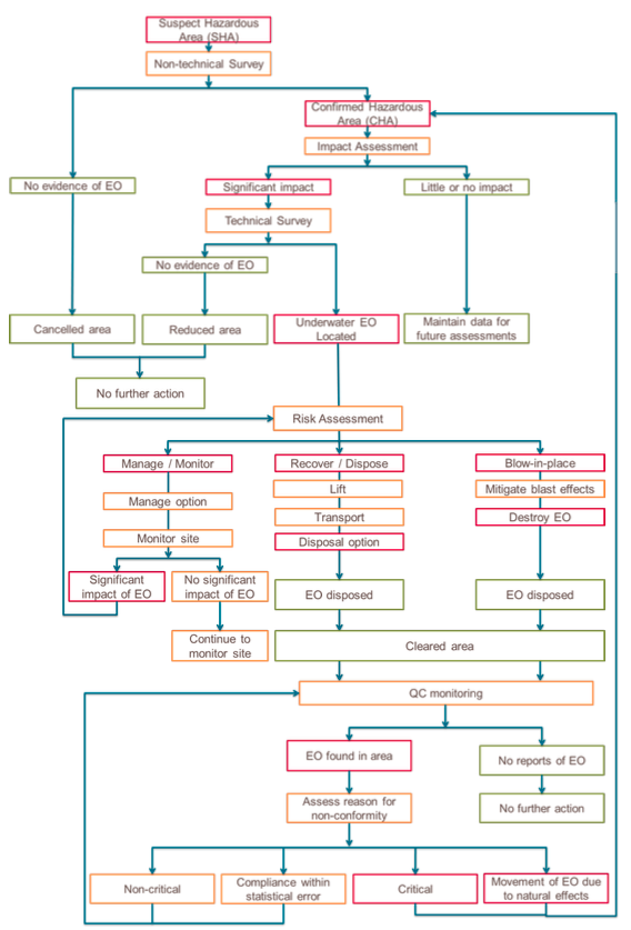
The below diagram provides an outline of the underwater EO survey and clearance process. In practice, the process may not be sequential; however, the outline indicates the general sequence and logical progression.
Annex C (Informative): Risk Management Framework
Below is an example of a four step risk management framework that can be used to assess and manage activities that involve risk.
Step 1 – identify the hazard
Hazards are physical activities conducted on site. (Examples include: diving operations, demolition operations and small boat operations).
Step 2 – identify the associated threats
Threats are defined based on the historic evidence and likelihood of occurrence. (Examples of threats in diving operations include: decompression sickness, arterial gas embolism and mechanical injury).
Step 3 – develop a risk assessment matrix

Step 4 – institute a risk mitigation strategy then reassess (example of process in below chart)

Amendment record
Management of IMAS amendments
The IMAS series of standards are subject to formal review on a three-yearly basis, however this does not preclude amendments being made within these three-year periods for reasons of operational safety and efficiency or for editorial purposes.
As amendments are made to this IMAS they will be given a number, and the date and general details of the amendment shown in the table below. The amendment will also be shown on the cover page of the IMAS by the inclusion under the edition date of the phrase ‘incorporating amendment number(s) 1 etc.’
As the formal reviews of each IMAS are completed new editions may be issued. Amendments up to the date of the new edition will be incorporated into the new edition and the amendment record table cleared. Recording of amendments will then start again until a further review is carried out.
The most recently amended IMAS will be the versions that are posted on the IMAS website at www.mineactionstandards.org.
| Number | Date | Amendment details |
|---|---|---|
Footnote
1 Underwater survey and clearance of EO in support of humanitarian tasks should not be conducted in areas where naval minefields containing live influence ordnance are suspected of being present. In areas where chemical munitions are suspected, EOD personnel specially trained and equipped in chemical munition response and disposal are required.
2 It is preferable to make EO a land-based problem when reasonable efforts can be made to remove water from an EO site or wait until tides subside. Clearance of areas deeper than 50 meters of water fall outside humanitarian operations as defined in this standard due to the limited socio-economic and safety impact of deeper water sites.
3 A new IMAS to address overall Quality Management is planned in order to provide general principles and a framework for the process.