Warning
This document is distributed for use by the mine action community, review and comment. Although in a similar format to the International Mine Action Standards (IMAS) it is not part of the IMAS Series. It is subject to change without notice and may not be referred to as an International Mine Action Standard.
Recipients of this document are invited to submit, with their comments, notification of any relevant patent rights of which they are aware and to provide supporting documentation. Comments should be sent to mineaction@un.org with a copy to imas@gichd.org.
The content of this document has been drawn from open source information and has been technically validated as far as reasonably possible. Users should be aware of this limitation when utilising the information contained within this document. They should always remember that this is only an advisory document: it is not an authoritative directive.
Foreword
Management practices and operational procedures for humanitarian mine action are constantly evolving. Improvements are made, and changes are required, to enhance safety and productivity. Changes may come from the introduction of new technology, in response to a new mine or ERW threat, and from field experience and lessons learned in other mine action projects and programmes. This experience and lessons learned should be shared in a timely manner.
Technical Notes provide a forum to share experience and lessons learned by collecting, collating and publishing technical information on important, topical themes, particularly those relating to safety and productivity. Technical Notes complement the broader issues and principles addressed in International Mine Action Standards (IMAS).
Technical Notes are not formally staffed prior to publication. They draw on practical experience and publicly-available information. Over time, some Technical Notes may be 'promoted' to become full IMAS standards, while others may be withdrawn if no longer relevant or if superseded by more up-to-date information.
Technical Notes are neither legal documents nor IMAS. There is no legal requirement to accept the advice provided in a Technical Note. They are purely advisory and are designed solely to supplement technical knowledge or to provide further guidance on the application of IMAS.
Technical Notes are compiled by the Geneva International Centre for Humanitarian Demining (GICHD) at the request of the United Nations Mine Action Service (UNMAS) in support of the international mine action community. They are published on the IMAS website at www.mineactionstandards.org.
Introduction
The Geneva International Centre for Humanitarian Demining (GICHD) has developed a set of map symbols that is in line with the IMAS 07.11 Land Release. The land release process is associated with geographic areas undergoing a series of activities aimed at releasing hazardous areas for productive use. Since mine action is inherently geographic, Geographic Information Systems (GIS) perform an important role in the management and analysis of land release data, and facilitate evidence-based decision making for planning, prioritization, reporting and monitoring. Serving as the graphical language on maps, intuitive cartographic symbols allow for a clear and standardized representation of the land release process and are thereby beneficial for promoting consistency, efficiency and safety in survey and clearance operations.1
The symbology takes into account the basic information requirements of the land release process by representing priority land and activity attribute values. The 11 point and 8 polygon symbols visualizing various land values, as well as 13 point symbols illustrating mine action activity values are listed as Annex C to the IMAS 07.11 Land Release.
The new land release symbols can be downloaded in different GIS compatible formats (style files and true font files) to be used for various desktop and web applications, such as IMSMA, ArcGIS Desktop, ArcGIS Online, Google Earth, and others. The image URLs of point-symbols and detailed description of the polygon symbols are available on IMSMA Wiki (http://mwiki.gichd.org/IM/Symbology). The symbols are further integrated in the ESRI style library for ArcGIS Online.
1. Scope
This Technical Note provides a justification for a new land release symbology and describes the methodology and design considerations applied during the development of the cartographic symbols. Furthermore, the Technical Note offers guidance to Information Management and GIS personnel on how to implement the symbols in GIS products.
2. Normative references
A list of normative references is given in Annex A. This list is referred to in the standard and forms part of the standard’s provisions.
3. Terms, definitions and abbreviations
A complete glossary of all the terms and definitions used in the IMAS series and Technical Notes is given in IMAS 04.10.
In the Technical Notes series, the words “should” and “may” are used to indicate the intended degree of compliance. This use is consistent with the language used in (International Organisation for Standardisation (ISO) standards and guidelines.
-
Should is used to indicate the preferred requirements, methods or specifications.
-
May is used to indicate a possible method or course of action.
The term “Land Release” describes the process of applying all reasonable effort to identify, define, and remove all presence and suspicion of mines/ERW through non-technical survey, technical survey and/or clearance. The criteria for “all reasonable effort” shall be defined by the NMAA.
Confirmed Hazardous Area (CHA)
An area where the presence of mine/ERW contamination has been confirmed on the basis of direct evidence of the presence of mines/ERW.
Suspected Hazardous Area (SHA)
An area where there is reasonable suspicion of mine/ERW contamination on the basis of indirect evidence of the presence of mines/ERW.
Cancelled land (m2)
A defined area concluded not to contain evidence of mine/ERW contamination following the non-technical survey of a SHA/CHA.
Reduced land (m2)
A defined area concluded not to contain evidence of mine/ERW contamination following the technical survey of a SHA/CHA.
Cleared land (m2)
A defined area cleared through the removal and/or destruction of all specified mine and ERW lands to a specified depth.
Explosive Remnants of War (ERW)
Explosive remnants of war means unexploded ordnance and abandoned explosive ordnance. [CCW protocol V]
Anti-Personnel Mines (APM)
A mine designed to be exploded by the presence, proximity or contact of a person and that will incapacitate, injure or kill one or more persons. [APMBC]
Anti-Vehicle Mines (AVM)
A mine designed to detonate by the presence, proximity or contact of a vehicle. [APMBC]
Unexploded Ordnance (UXO)
Explosive ordnance that has been primed, fuzed, armed or otherwise prepared for use or used. It may have been fired, dropped, launched or projected, yet it remains unexploded either through malfunction or design or for any other reason.
Cluster munition (CM)
Note: The following definition of cluster munition is for political purposes as defined in the CCM.
Cluster munition refers to a conventional munition that is designed to disperse or release explosive sub-munitions each weighing less than 20 kilograms, and includes those explosive sub-munitions. [CCM]
It does not include the following:
-
a munition or sub-munition designed to dispense flares, smoke, pyrotechnics or chaff; or a munition designed exclusively for an air defence role;
-
a munition or sub-munition designed to produce electrical or electronic effects;
-
munition that in order to avoid indiscriminate area effects and the risks posed by unexploded sub-munitions, has all of the following characteristics:
-
each munition contains fewer than 10 explosive sub-munitions;each explosive sub-munition weighs more than four kilograms;
-
each explosive sub-munition is designed to detect and engage a single target object;
-
each explosive sub-munition is equipped with an electronic self-destruction mechanism;
-
each explosive sub-munition is equipped with an electronic self-deactivating feature.
-
Abandoned Explosive Ordnance (AXO)
Explosive ordnance that has not been used during an armed conflict, that has been left behind or dumped by a party to an armed conflict, and which is no longer under control of the party that left it behind or dumped it. Abandoned explosive ordnance may or may not have been primed, fuzed, armed or otherwise prepared for use. [CCW protocol V]
Explosive Ordnance Disposal (EOD)
The detection, identification, evaluation, render safe, recovery and disposal of EO. EOD may be undertaken:
-
as a routine part of mine clearance operations, upon discovery of ERW;
-
to dispose of ERW discovered outside hazardous areas, (this may be a single item of ERW, or a larger number inside a specific area); or
-
to dispose of EO which has become hazardous by deterioration, damage or attempted destruction.
Non-technical Survey
The collection and analysis of data, without the use of technical interventions, about the presence, type, distribution and surrounding environment of mine/ERW contamination, in order to define better where mine/ERW contamination is present, and where it is not, and to support land release prioritisation and decision-making processes through the provision of evidence.
Technical Survey
The term refers to the collection and analysis of data, using appropriate technical interventions, about the presence, type, distribution and surrounding environment of mine/ERW contamination, in order to define better where mine/ERW contamination is present, and where it is not, and to support land release prioritisation and decision making processes through the provision of evidence.
Clearance
In the context of mine action, the term refers to tasks or actions to ensure the removal and/or the destruction of all mine and ERW lands from a specified area to a specified depth.
Mechanical Methods
In the context of mine action, the term refers to tasks or actions to ensure the detection and/or removal and/or the destruction of mine and ERW hazards from a specified area by using machines, which may involve a single machine employing one mechanical tool, a single machine employing a variety of tools or a number of machines employing a variety of tools
Manual Methods
In the context of mine action, the term refers to tasks or actions to ensure the detection and/or removal and/or the destruction of all mine and ERW hazards from a specified area conducted by deminers.
Animal Methods
In the context of mine action, the term refers to tasks or actions conducted by animals, trained and employed to detect mines, ERW and other explosive devices from a specified area.
Surface Clearance
The term refers to an activity that seeks to systematically remove and/or destroy cluster munition remnants (CMR) or other ERW found on the surface of the ground from a specified area. This type of activity is often completed as an emergency exercise in the immediate aftermath of conflict in areas known not to contain mines.
Sub-surface Clearance
The term refers to clearance - to physically and systematically process an area to ensure the removal and/or destruction of all mine and ERW hazards to a specified depth (the depth to which a specified area is contracted or agreed to be cleared of mine and ERW hazards, as determined by the NMAA or an organisation acting on its behalf).
Geographical (or Geospatial) Information System (GIS)
An organised collection of computer hardware, software, geographic data, and personnel designed to efficiently capture, store, update, manipulate, analyse, and display all forms of geographically referenced information.
Note: GIS allows a user to graphically view multiple layers of data based on their geographic distribution and association. GIS incorporates powerful tools to analyse the relationships between various layers of information.
Feature
A representation of a real-world object on a map. [ESRI GIS dictionary]
Feature class
Feature classes are homogeneous collections of common features, each having the same spatial representation, such as points, lines, or polygons, and a common set of attribute columns. [ESRI GIS dictionary]
Attribute
Non-spatial information about a geographic feature in a GIS, usually stored in a table and linked to the feature by a unique identifier. For example, attributes of a river might include its name, length, and sediment load at a gauging station. [ESRI GIS dictionary]
Attribute Value
A specific quality or quantity assigned to an attribute for a specific entity instance. [Federal Geographic Data Committee]
Polygon
On a map, a closed shape defined by a connected sequence of x,y coordinate pairs, where the first and last coordinate pairs are the same and all other pairs are unique. [ESRI GIS dictionary]
Point
A geometric element defined by a pair of x,y coordinates. [ESRI GIS dictionary]
Symbol
A graphic used to represent a geographic feature or class of features. Symbols can look like what they represent (trees, railroads, houses), or they can be abstract shapes (points, lines, polygons) or characters. Symbols are usually explained in a map legend. [ESRI GIS dictionary]
Symbology
The set of conventions, rules, or encoding systems that define how geographic features are represented with symbols on a map. A characteristic of a map feature may influence the size, colour and shape of the symbol used. [ESRI GIS dictionary]
4. Revisiting the Land Release symbology
In 2005 a standard set of cartographic symbols for mine action were developed by the GICHD and the University of Kansas. These recommendations were published in a report entitled “Cartographic Recommendations for Humanitarian Demining Map Symbols in the Information Management System for Mine Action (IMSMA)”. With the adoption of the IMAS 07.11 Land Release in 2009 and its major amendment in 2013 there was a need to review the existing symbology and to create new symbols that conform to these standards.
The land release symbology tries to capture the main attribute values required to depict the many categories of lands and mine action activities on maps, taking into account the needs of different audiences, such as national mine action authorities, operators and donors. It does not include symbols for other mine action objects such as task, quality control, mine/demining accident, victim, victim assistance, and mine risk education. The aim of the land release symbology is thus to improve land and activity symbols that already exist and adds new symbols to cover important attribute values to be represented during the land release process. For instance, essential attributes such as land release products, activity types, status and evidence points have not been considered by the previous symbol set.
Displaying land release data on maps using standardized symbols is crucial for safe and efficient survey and clearance operations. It is important that the symbols are not ambiguous or confusing but clear and intuitive to map users in order to avoid any misinterpretation of maps that may lead to an increased risk of accidents. By conveying messages on maps, a standardized symbol set for the land release process promotes clear and consistent communication on mine/ERW contamination and the progress of operations between all mine action stakeholders. It improves comprehension and fosters efficiency by reducing the time required to convert symbols correctly into their real-world meaning, as well as supports information exchange between mine action actors by offering a common graphical language on maps.2
5. Methodology
Before designing new symbols, a systematic review of the below symbol libraries was conducted. This evaluation affirmed the need for a new set of symbols representing the land release process.
- ESRI ArcGIS symbol library3
- NATO Military Symbols for Land Based Systems4
- Recommended symbols for IMSMA5
- OCHA humanitarian symbols6
- International Organisation for Standardisation (ISO) symbols7
- UNHCR symbol set8
- Map Action field guide to humanitarian mapping9
In order to create a list of required symbols, thematic maps frequently used in humanitarian mine action were identified. Based on these map categories, priority features, attributes, and their values to be geo-represented during the land release process were listed in a matrix for each of which a distinct symbol was created (Figure 1).
| Types of Maps | Feature | Attributes | Values |
|---|---|---|---|
| Land classification, status, contamination type | Land | Classifications | CHA SHA |
| Land classification, status, contamination type | Land | Status | Open Worked on Closed |
| Land classification, status, contamination type | Land | Land Release product | Cancelled Reduced Cleared |
| Land classification, status, contamination type | Land | Type of contamination | APM AVM UXO CM AXO Unknown |
| Types of Maps | Feature | Attributes | Values |
|---|---|---|---|
| Activity type, method, status | Activity | Type | EOD Spot Task NTS TS Clearance |
| Activity type, method, status | Activity | Method | Mechanical Manual Animal |
| Activity type, method, status | Activity | Status | Planned Ongoing Completed |
| Activity type, method, status | Activity | Spatial dimension | Surface Sub-surface |
| Activity type, method, status | Activity | Point type | Evidence point |
Figure 1: Land Release symbology matrix
Based on the above table, 32 point and polygon symbols were designed by the Geneva-based communication and web-design agency PaPerPlane10 in 2014 and 2015, under continuous direction by, and in close collaboration with, the GICHD. ISO representatives provided advice and guided the GICHD at the beginning of the design process.
An important step in the development of the land release symbols was the review of the draft symbols by a focus group. Sixty-three survey responses from national mine action authorities, UN agencies, international mine action operators, NGOs, donor representatives and independent consultants were received. This evaluation was decisive for the final selection and design of the symbols. During the evaluation process, symbols were presented in two formats. In some cases, several symbol options were given, and evaluators were asked to choose their preferred one. The symbol that received the majority of votes was selected. In other cases, one symbol option was given, and evaluators were requested to state their agreement or disagreement with the suggested symbol. In this scenario, a minimum of 70% acceptance was required to pass the evaluation without further modifications. Survey participants were also asked to provide comments, ideas and suggestions regarding any further improvements that could be made to each symbol, if they were not convinced of its usefulness, clarity or scalability.
The evaluation results as well as any written suggestions were tabulated for each symbol. Such information guided further modifications. Improvements notably included the use of colour coding for land and activity status attributes, changes of icon shapes for the land status attribute values ‘open’ and ‘worked on’, revision of icons for the contamination type attribute values ‘APM’ and AVM’ and modifications of the symbols for the activity type attribute values ‘clearance’ and ‘technical survey’.
All point and polygon symbols were converted to GIS compatible formats to be used for various desktop and web applications, such as IMSMA, ArcGIS Desktop, ArcGIS Online, Google Earth, and others. Symbols are available in style files and true font files. For usage in online applications, the image URLs of point symbols as well as a detailed description of the polygon symbols are available on IMSMA Wiki (http://mwiki.gichd.org/IM/Symbology). The symbols are further integrated in the ESRI style library for ArcGIS Online.
6. Design considerations
During the development of the symbols certain principles and criteria regarding the symbol design were considered. Most importantly, the symbols are intended to be simple and intuitive in order to be easily comprehended by information management and operational staff as well as by civilians and donor representative. Therefore, the symbols resemble as much as possible the real world features that they try to represent11 in order to be easily associated with their intended meaning12 in the absence of a map legend. Only a few of the symbols are more abstract than representational in their form.
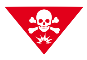
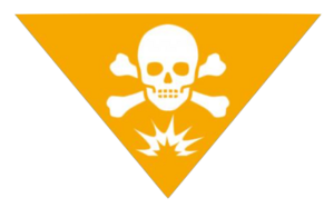
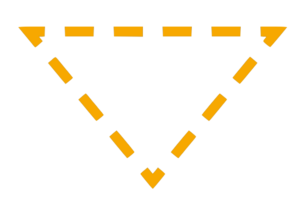
A further consideration was to ensure that a new symbol is not already in use to represent another meaning. This was guaranteed by a systematic review of existing symbol libraries (see Chapter 5). The only exception concerns the CHA/SHA symbols, which are similar to the symbol representing toxic material in ISO International Standard 7010 (Figure 2). It was decided to keep the icon representing a skull and crossbones since it is commonly used by the humanitarian mine action community to symbolize hazards on maps as well as for hazardous area marking (IMAS 08.40). However, the CHA/SHA symbols differ from the toxic material warning symbol by a reverse triangle shape, an additional explosion sign and a different skull and crossbones design.
| ISO Warning toxic material symbol | Confirmed Hazardous Area (CHA) symbol |
|---|---|
 |  |
Figure 2: Comparison of ISO warning toxic material symbol and CHA symbol
In order to facilitate readability on maps as well as easy interpretation across countries and cultures, no letters or words were used in the symbols.
Furthermore, appropriate colours were selected based on their symbolic meanings. Traffic light colours are used by many humanitarian mine action organizations to depict different classification of lands (red and orange) and safe areas (green) as well as different activity and land status values. Also IMAS 08.40 specifies red and orange as the background colour for hazard signs.13 The colour selection is further based on the guidelines of the ISO (e.g. red = danger and prohibition; orange = warning; green = safety)14. Therefore, green is used for symbols that represent released/closed land and completed activities to communicate safety. Red was selected for confirmed land symbols and open statuses as it connotes danger. Orange was chosen to represent suspected or worked-on hazards and ongoing activities. Where traffic light colours would not add any benefit, point symbols were created in black and
white which provides a high contrast and is best suited for printing. Importantly, colours enhance comprehension but the entire symbol set can be printed in black and white, as lightness/darkness, shapes, icons and outlines were used to differentiate between the symbols in the absence of colours. The above described colour convention is a recommendation that has guided the design of the land release symbology but since the meaning of colours varies among cultures, flexibility in the colour choice is permissible.15
Topographic maps, satellite imagery and aerial photographs are often used as base maps in GIS software to display mine action data. These base maps contain important information such as land use, location of roads, vegetation, etc. Therefore, polygon symbols either have transparent colour fills or their pattern fills have transparent space in between to ensure that underlying base maps are visible.
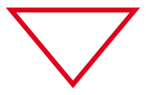
Point symbols of the symbology have three different shape forms. Land classification symbols are triangles – a shape that is commonly used for hazard marking signs and which is associated with danger and warning.16 Point symbols representing an activity status as well as closed/released land are circles to visualize process. Polygon and point outlines were developed to depict land status values. All other point symbols have a square form design.
7. General principles of implementation
Mine action maps are produced for a variety of purposes at different scales with different levels of detail requirements, depending on the map audience. The land release symbology includes point and polygon symbols that can be used for large-scale maps of individual hazardous areas and small-scale national or regional maps of multiple areas. The point and polygon symbols representing the same value for the land attributes ‘classification’, ‘status’ and ‘land release product’ were designed in a way that map users can easily link the two symbols with changing map scales (Figure 3).17

Figure 3: CHA symbols displayed on small and large scale
The land attribute ‘land release product’ is a special case when it comes to scalability. For each attribute value a different polygon symbol was created, representing the products of the land release process, namely ‘cancelled land’, ‘reduced land’ and ‘cleared land’. A released land can be composed of a cancelled area, a part that has been reduced and another part that has been cleared. This level of detail can only be displayed on a large scale map. On a small scale map, the more general information ‘released land’ is represented with a point symbol (Figure 4).

Figure 4: CHA and released land symbols displayed on small scale and cancelled, reduced and cleared polygon symbols displayed on large scale
The land release symbol set follows a structure that allows for a more specific symbolization depending on the level of detail required. Depending on the map audience and its purpose, general or specific data on the land release process needs to be represented. For instance, maps for the public or donors display general information on the location of hazards or the progress of the land release process. On the other hand, maps for operational staff seek to communicate more specific information related to the identified hazards such as its status or the type of contamination, as well as the activity type and method used on a specific land. This is achieved by combining value attribute layers which are represented through points, polygon fills and outline symbols. For example, it is proposed to combine the land classification layer represented by a point and polygon fill (depending on the scale) with the land status layer represented by a point or polygon outline (depending on the scale) with the result of showing more detailed information on a map (Figure 5).

Since mine action activities always happen on a land which is itself described by a polygon, no polygon symbols were developed for the activity feature as a second polygon would be redundant. For a large scale map showing one or multiple lands displayed as polygons symbols, it is therefore recommended to add the activity point symbol to the land polygon to indicate the relationship between the features.18 On a large scale map, the land classification polygon can be combined with activity points representing activity method, type or status, as well as spatial dimension and evidence point (Figure 6). This logic can also be applied to related point and polygon symbols of the same feature. For instance, in addition to the land classification polygon, the type of contamination point symbol can be placed in the center of the polygon to provide another layer of information (Figure 7).
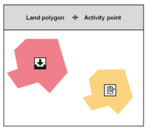
Figure 6: Combining the ‘land classification’ polygon symbols with ‘activity type’ point symbols to indicate the relationship between features
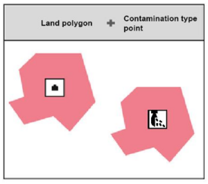
Figure 7: Combining the ‘land classification’ polygon symbol with ‘contamination type’ point symbols to relate point and polygon symbols of the same feature
Due to the hierarchical structure of the symbology, more than two attribute layers can be combined on large scale maps. To achieve a high level of detail, a graphic component (e.g. fill color/pattern, border, icon, etc.) is added to symbolize an additional attribute (Figure 8).19
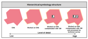
Figure 8: Example of a hierarchical symbol for worked on CHA contaminated with Cluster Munitions (CM) and processed by technical survey
In order to keep the map comprehensible, only one attribute layer, represented by different point symbols, should be displayed on small scale maps. Exception to this general implementation principle constitutes the attributes ‘land classification’, ‘land status’ and ‘land release product’. As mentioned above, the ‘land classification’ layer can be combined with the ‘land status’ layer on small scale maps to increase the level of detail displayed (Figure 5). In case of the ‘land release product’ attribute, it is recommended to add the ‘land classification’ layer on a small scale map to inform about the progress of the land release process. Such a map would display the location of the previous hazards that have been released as well as the locations of CHAs and SHAs. The more detailed values of this attribute, namely ‘cancelled’, ‘reduced’ and ‘cleared’ land are only visible on a large scale map (Figure 4).
8. Land Release symbol recommendations
8.1. Feature: Land
8.1.1. Attribute: Classification
| Image | Value | Symbol type | Symbol content | Function |
|---|---|---|---|---|
 | CHA | Polygon | Fill colour CMYK 0 100 100 0 RGB 255 0 0 HEX FF0000 Transparency - 50% | To indicate the location of a CHA on large scale maps. |
| Additional information |
|---|
Red is the common colour to visualize danger. IMAS 08.40 specifies red and orange as the background colour for hazard signs.20 The transparent red fill of the polygon symbol does not block underlying topographic maps and imagery. |
| Image | Value | Symbol type | Symbol content | Function |
|---|---|---|---|---|
 | CHA | Point | Colour CMYK 0 100 100 0 RGB 255 0 0 HEX FF0000 Shape - Triangle Icon - Skull, crossbones, explosion | To indicate the location of a CHA on large scale maps. |
| Additional information |
|---|
Red is the common colour to visualize danger. IMAS 08.40 specifies red and orange as the background colour for hazard signs. It details that the universal symbol for danger is the skull and crossbones.21 |
| Image | Value | Symbol type | Symbol content | Function |
|---|---|---|---|---|
 | SHA | Polygon | Fill colour CMYK 0 40 100 0 RGB 244 167 24 HEX F4A718 Transparency - 50% | To indicate the location of a SHA on large scale maps. |
| Additional information |
|---|
Orange is the common colour to visualize warning. IMAS 08.40 specifies red and orange as the background colour for hazard signs.22 The transparent orange fill of the polygon symbol does not block underlying topographic maps and imagery. |
| Image | Value | Symbol type | Symbol content | Function |
|---|---|---|---|---|
 | SHA | Point | Colour CMYK 0 40 100 0 RGB 244 167 24 HEX F4A718 Shape - Triangle | To indicate the location of a SHA on large scale maps. |
| Additional information |
|---|
Orange is the common colour to visualize warning. IMAS 08.40 specifies red and orange as the background colour for hazard signs. It details that the universal symbol for danger is the skull and crossbones.23 |
8.1.2. Attribute: Status
| Image | Value | Symbol type | Symbol content | Function |
|---|---|---|---|---|
 | Open | Polygon | Outline colour CMYK 0 100 100 0 RGB 255 0 0 HEX FF0000 Outline - Continuous | To indicate the location of an open land (CHA or SHA) on a large scale map. The land has been reported but no activities have taken place to reduce or clear it. |
| Additional information |
|---|
It is recommended to use the land status layer in combination with the land classification layer (8.1.1). The status symbol adds another graphical element (outline) for a higher level of detail. |
| Image | Value | Symbol type | Symbol content | Function |
|---|---|---|---|---|
 | Open | Point | Outline colour CMYK 0 100 100 0 RGB 255 0 0 HEX FF0000 Outline - Continuous Shape - Triangle | To indicate the location of an open land (CHA or SHA) on a large scale map. The land has been reported but no activities have taken place to reduce or clear it. |
| Additional information |
|---|
It is recommended to use the land status layer in combination with the land classification layer (8.1.1). The status symbol adds another graphical element (outline) for a higher level of detail. |
| Image | Value | Symbol type | Symbol content | Function |
|---|---|---|---|---|
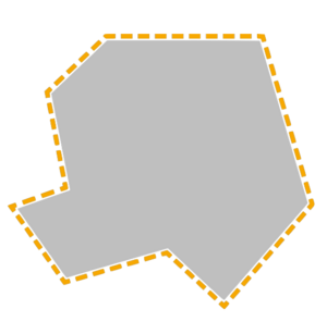 | Worked on | Polygon | Outline colour CMYK 0 40 100 0 RGB 244 167 24 HEX F4A718 Outline pattern
| To indicate the location of an open land (CHA or SHA) on a large scale map. The land has been reported but no activities have taken place to reduce or clear it. |
| Additional information |
|---|
| It is recommended to use the land status layer in combination with the land classification layer (8.1.1). The status symbol adds another graphical element (outline) for a higher level of detail. |
| Image | Value | Symbol type | Symbol content | Function |
|---|---|---|---|---|
 | Worked on | Point | Outline colour CMYK 0 40 100 0 RGB 244 167 24 HEX F4A718 Outline - Dotted (see above) Shape - Triangle | To indicate the location of an open land (CHA or SHA) on a large scale map. The land has been reported but no activities have taken place to reduce or clear it. |
| Additional information |
|---|
It is recommended to use the land status layer in combination with the land classification layer (8.1.1). The status symbol adds another graphical element (outline) for a higher level of detail. |
| Image | Value | Symbol type | Symbol content | Function |
|---|---|---|---|---|
 | Closed | Polygon | Outline colour CMYK 40 0 100 0 RGB 192 218 48 HEX C0DA30 Outline - Continuous | To indicate the location of a previously hazardous area that has been released on a large scale map. |
| Additional information |
|---|
This outline symbol representing closed land is further used for the land release product polygons because when a land is released its status is closed (8.1.3). |
| Image | Value | Symbol type | Symbol content | Function |
|---|---|---|---|---|
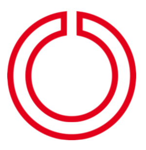
 | Closed | Point | Outline colour CMYK 40 0 100 0 RGB 192 218 48 HEX C0DA30 Outline - Continuous Shape - Ring | To indicate the location of a previously hazardous area that has been closed/released on a small scale map. |
| Additional information |
|---|
The closed status symbol is identic to the released land symbol because when a land is released, its status is closed (8.1.3). |
8.1.3. Attribute: Land Release product
| Image | Value | Symbol type | Symbol content | Function |
|---|---|---|---|---|
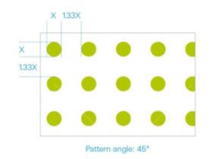
 | Cancelled | Polygon | Outline colour CMYK 40 0 100 0 RGB 192 218 48 HEX C0DA30 Fill pattern
Outline - continuous | To indicate the location of a previously hazardous area that has been closed/released on a small scale map. |
| Additional information |
|---|
The closed status symbol is identic to the released land symbol because when a land is released, its status is closed (8.1.3). |
| Image | Value | Symbol type | Symbol content | Function |
|---|---|---|---|---|
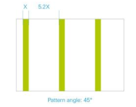
 | Reduced | Polygon | Outline colour CMYK 40 0 100 0 RGB 192 218 48 HEX C0DA30 Fill pattern
Outline - continuous | To indicate the location of a land that has been reduced through technical survey on a large scale map. |
| Additional information |
|---|
The land release product polygons contain the closed status outline symbol because when a land is closed it is also released (8.1.2). |
| Image | Value | Symbol type | Symbol content | Function |
|---|---|---|---|---|
| Cleared | Polygon | Outline colour CMYK 40 0 100 0 RGB 192 218 48 HEX C0DA30 Transparency - 50% Outline - continuous | To indicate the location of a land that has been cleared through clearance on a large scale map. |
| Additional information |
|---|
The land release product polygons contain the closed status outline symbol because when a land is closed it is also released (8.1.2). |
| Image | Value | Symbol type | Symbol content | Function |
|---|---|---|---|---|
 | Released | Point | Outline colour CMYK 40 0 100 0 RGB 192 218 48 HEX C0DA30 Shape - ring | To indicate the location of released land on a small scale map. There is no distinction between cancelled, reduced and cleared land at this scale. |
| Additional information |
|---|
The closed status symbol is identic to the release land symbol because when a land is released, it is also closed (8.1.2). |
8.1.4. Attribute: Type of contamination
| Image | Value | Symbol type | Symbol content | Function |
|---|---|---|---|---|
 | APM | Point | Colour - Black/White Outline - Continuous Shape - Square Icon - APM | On a small scale map to indicate the location of a land contaminated by anti-personnel mines. On a large scale map, the point symbol is added to the centre of the land polygon symbol to indicate that the location area is contaminated by anti-personnel mines. |
| Image | Value | Symbol type | Symbol content | Function |
|---|---|---|---|---|
 | AVM | Point | Colour - Black/White Outline - Continuous Shape - Square Icon - AVM | On a small scale map to indicate the location of a land contaminated by anti-vehicle mines. On a large scale map, the point symbol is added to the centre of the land polygon symbol to indicate that the location area is contaminated by anti-vehicle mines. |
| Image | Value | Symbol type | Symbol content | Function |
|---|---|---|---|---|
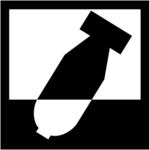 | UXO | Point | Colour - Black/White Outline - Continuous Shape - Square Icon - Mortar stuck in ground | On a small scale map to indicate the location of a single UXO item or a specific area containing a larger number of UXO. On a large scale map, the point symbol is added to the centre of the land polygon symbol to indicate that the location is contaminated by a larger number of UXO. In case of a single UXO item no polygon symbol is required. |
| Image | Value | Symbol type | Symbol content | Function |
|---|---|---|---|---|
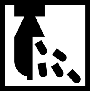 | CM | Point | Colour - Black/White Outline - Continuous Shape - Square Icon - Explosive ordnance releasing sub-munitions | On a small scale map to indicate the location of a land contaminated by cluster munitions. On a large scale map, the point symbol is added to the centre of the land polygon symbol to indicate that the area is contaminated by cluster munitions. |
| Image | Value | Symbol type | Symbol content | Function |
|---|---|---|---|---|
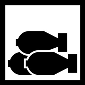 | AXO | Point | Colour - Black/White Outline - Continuous Shape - Square Icon - Three mortar neatly puled up | On a small scale map to indicate the location of AXO. On a large scale map, the point symbol is added to the centre of the land polygon symbol to indicate that the area is contaminated by a larger number of AXO. |
| Image | Value | Symbol type | Symbol content | Function |
|---|---|---|---|---|
 |
Unknown | Point | Colour - Black/White Outline - Continuous Shape - Square Icon - Square with a question mark in the ground | On a small scale map to indicate the location of a land contaminated by unknown ordnances. On a large scale map, the point symbol is added to the centre of the land polygon symbol to indicate that the area is contaminated by unknown ordnances. |
To show the mixed contamination on a map, the GIS officer should combine different variations of expected contamination types into one: AV, AP, CM, UXO (Figure 9).
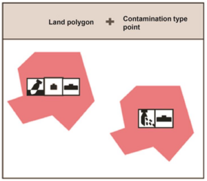
Figure 9: Example of the representation of mixed contamination
8.2 Feature: Activity
8.2.1 Attribute: Type
| Image | Value | Symbol type | Symbol content | Function |
|---|---|---|---|---|
 | EOD Spot Task | Point | Colour - Black/White Outline - Continuous Shape - Square Icon - White spot on a black ground | To indicate the location of disposal activity of explosive ordnance(s). |
| Image | Value | Symbol type | Symbol content | Function |
|---|---|---|---|---|
 |
Technical Survey | Point | Colour - Black/White Outline - Continuous Shape - Square Icon - Clipboard and a pen | On a small scale map to indicate the location of a non-technical survey activity. On a large scale map, the point symbol is added to the center of the land polygon symbol to relate the land to the non-technical survey activity |
| Image | Value | Symbol type | Symbol content | Function |
|---|---|---|---|---|
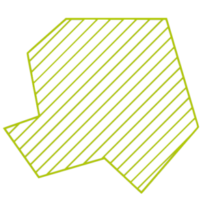
 |
Technical Survey | Point | Colour - Black/White Outline - Continuous Shape - Square Icon - Lines in an area | On a small scale map to indicate the location of a technical survey activity. On a large scale map, the point symbol is added to the center of the land polygon symbol to relate the land to the technical survey activity. |
| Image | Value | Symbol type | Symbol content | Function |
|---|---|---|---|---|
Clearance | Point | Colour - Black/White Outline - Continuous Shape - Square Icon - Hole in the ground with an arrow pointing to it | On a small scale map to indicate the location of a clearance activity. On a large scale map, the point symbol is added to the center of the land polygon symbol to relate the land to the clearance activity. |
8.2.2. Attribute: Method
| Image | Value | Symbol type | Symbol content | Function |
|---|---|---|---|---|
 | Mechanical | Point | Colour - Black/White Outline - Continuous Shape - Square Icon - Wheel of a demining machine used on the ground | On a small scale map to indicate the location of a mechanical activity. On a large scale map, the point symbol is added to the center of the land polygon symbol to relate the land to the mechanical activity method. |
| Image | Value | Symbol type | Symbol content | Function |
|---|---|---|---|---|
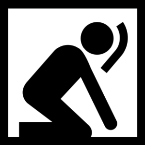 | Manual | Point | Colour - Black/White Outline - Continuous Shape - Square Icon - Demining worker probing for landmines | On a small scale map to indicate the location of a manual activity. On a large scale map, the point symbol is added to the center of the land polygon symbol to relate the land to the manual activity method. |
| Image | Value | Symbol type | Symbol content | Function |
|---|---|---|---|---|
 | Animal | Point | Colour - Black/White Outline - Continuous Shape - Square Icon - Head of a dog and a rat | On a small scale map to indicate the location of an animal detection activity. On a large scale map, the point symbol is added to the center of the land polygon symbol to relate the land to the animal detection activity method. |
8.2.3. Attribute: Status
| Image | Value | Symbol type | Symbol content | Function |
|---|---|---|---|---|
 | Planned | Point | Colour
Shape - Circle Icon - Outlined ring | To indicate the location of a planned activity. |
| Image | Value | Symbol type | Symbol content | Function |
|---|---|---|---|---|
 | Ongoing | Point | Colour
/
Shape - Circle Icon - Half outlined ring and filled arrow | To indicate the location of an ongoing activity. |
| Image | Value | Symbol type | Symbol content | Function |
|---|---|---|---|---|
 | Completed | Point | Colour
Shape - Circle Icon - Filled ring | To indicate the location of a completed activity. |
8.2.4. Attribute: Spacial dimension
| Image | Value | Symbol type | Symbol content | Function |
|---|---|---|---|---|
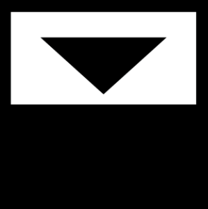 | Surface | Point | Colour - Black/White Outline - Continuous Shape - Square Icon - Triangle pointing to the ground | On a small scale map to indicate the location of surface clearance activity. On a large scale map, the point symbol is added to the center of a land polygon symbol to relate the land to the surface clearance activity |
 | Value Sub-surface |
Symbol type Point | |
Symbol content Colour - Black/White Outline - Continuous Shape - Square Icon - Triangle in the ground | |
Function
On a small scale map to indicate the location of sub-surface clearance activity. On a large scale map, the point symbol is added to the centre of a land polygon symbol to relate the land to the sub-surface clearance activity. |
8.2.5. Attribute: Point type
| Value Evidence Point |
Symbol type Point | |
Symbol content Colour - Black/White Outline - Continuous Shape - Square Icon - Magnifier | |
Function On a large scale map to indicate the location of direct or indirect evidence points. |

9. Practical use and inspiration maps
In order to use the land release symbology in GIS desktop applications, the true font files need to be downloaded and copied to the C:\Windows\Fonts directory. The style files can be added to existing ESRI style libraries for ArcGIS Desktop. For usage in online applications, the image URLs of point symbols as well as a detailed description of the polygon symbols are available on IMSMA Wiki (http://mwiki.gichd.org/IM/Symbology).The symbols are further integrated in the ESRI style library for ArcGIS Online. Sample maps using the land release symbology can be found on the following pages. No real data has been used for the creation of these maps


10. Bibliography
Geneva International Centre for Humanitarian Demining (GICHD) (2005), ‘Cartographic Recommendations for Humanitarian Demining Map Symbols in the Information Management System for Mine Action (IMSMA)’, Geneva, Switzerland, pp.1-2, Retrieved 22 June 2015, www.gichd.org/fileadmin/GICHD-resources/rec-documents/IMSMA-Symbology- FinalReport.pdf
ESRI (2004) ‘ArcGIS Symbol Library’, Retrieved 20 January 2014,
support.esri.com/en/knowledgebase/product- announcements/view/productid/66/metaid/854
International Organisation for Standardisation (ISO) (2008) ‘International Standard 9186-2: Graphical symbols - Test methods - Part 2: Method for testing perceptual quality’, Geneva
International Organisation for Standardisation (ISO) (2010) ‘International Standard 28564-1: Public information guidance systems - Part 1: Design principles and element requirements for location plans, maps and diagrams’, Geneva
International Organisation for Standardisation (ISO) (2011) ‘International Standard 7010: Graphical symbols - safety colours and safety signs - registered safety signs’, Geneva
International Organisation for Standardisation (ISO) (2012) ‘International Standard 3864-3: Graphical symbols - Safety colours and safety signs - Part 3: Design principles for graphical symbols for use in safety signs’, Geneva
International Organisation for Standardisation (ISO) (2014) ‘International Standard 9186-1: Graphical symbols - Test methods - Part 1: Methods for testing comprehensibility’, Geneva
Kostelnick, J.C., Dobson, J.E., Egbert, S.L., Dunbar, M.D. (2008) ‘Cartographic Symbols for Humanitarian Demining.’ In The Cartographic Journal, Vol. 45, No.1, pp. 18-31
Map Action (2009) ‘MapAction Field Guide to Humanitarian Mapping’, Retrieved 20 January 2014, http://www.mapaction.org/component/mapcat/download/2426.html?fmt=pdf
NATO (1986) ‘Military Symbols for Land Based Systems’, Retrieved 20 January 2014,
http://www.military.com/ResourcesSubmittedFiles/Military_Symbols_Guide.pdf
UNHCR (2009) UNHCR Symbol Set
United Nations Mine Action Service (UNMAS) (2013) ‘IMAS 08.40: Marking mines and ERW hazards’, 2nd ed., United Nations, New York
United Nations Office for the Coordination of Humanitarian affairs (OCHA) (2012) ‘Humanitarian and Country Icons’, Retrieved 20 January 2014, http://reliefweb.int/report/world/world-humanitarian-and-country-icons-2012
Annex A (Normative) References
The following documents, when referred to in the text of this Technical Guide, form part of the provisions of this guide
-
IMAS 04.10 Terms and definitions;
-
IMAS 07.11 Land Release;
-
IMAS 05.10 Information management for mine action
The latest version/edition of these references should be used. GICHD hold copies of all references used in this standard. A register of the latest version/edition of the IMAS standards, guides and references is maintained by GICHD, and can be read on the IMAS website (http://www.mineactionstandards.org/).
National mine action authorities, employers and other interested bodies and organisations should obtain copies before commencing mine action programmes.
Amendment record
Management of Technical Notes amendments
Technical Notes (TN) are subject to review on an ‘as required’ basis. As amendments are made to this TN they will be given a number, and the date and general details of the amendment shown in the table below. The amendment will also be shown on the cover page of the TN by the inclusion under the version date of the phrase ‘incorporating amendment number(s) 1 etc.’
As reviews of TN are made, new versions may be issued. Amendments up to the date of the new version will be incorporated into the new version and the amendment record table cleared. Recording of amendments will then start again until a further version is produced.
The most recently amended TN will be the versions that are posted on the IMAS website at www.mineactionstandards.org.
| Number | Date | Amendment Details |
|---|---|---|
Footnote
1Kostelnick, J.C., Dobson, J.E., Egbert, S.L., Dunbar, M.D. (2008) ‘Cartographic Symbols for Humanitarian Demining.’ In The Cartographic Journal, Vol. 45, No.1, p. 19
2Geneva International Centre for Humanitarian Demining (GICHD) (2005), ‘Cartographic Recommendations for Humanitarian Demining Map Symbols in the Information Management System for Mine Action (IMSMA)’, Geneva, pp.1-2, Retrieved 22 June 2015, www.gichd.org/fileadmin/GICHD- resources/rec-documents/IMSMA-Symbology-FinalReport.pdf
3ESRI (2004) ‘ArcGIS Symbol Library’, Retrieved 20 January 2014, http://support.esri.com/en/knowledgebase/product-announcements/view/productid/66/metaid/854
4NATO (1986) ‘Military Symbols for Land Based Systems’, Retrieved 20 January 2014, http://www.military.com/ResourcesSubmittedFiles/Military_Symbols_Guide.pdf
5GICHD (2005), Retrieved 22 June 2015, www.gichd.org/fileadmin/GICHD-resources/rec- documents/IMSMA-Symbology-FinalReport.pdf
6United Nations Office for the Coordination of Humanitarian affairs (OCHA) (2012) ‘Humanitarian and County Icons’, Retrieved 20 January 2014, reliefweb.int/report/world/world-humanitarian-and- country-icons 2012
7ISO 3864-3:2011; ISO 9186-1: 2014; ISO 9186-2: 2008; ISO 28564-1:2010
8UNHCR (2009) UNHCR Symbol Set
9Map Action (2009) ‘Map Action Field Guide to Humanitarian Mapping’, Retrieved 20 January 2014, http://www.mapaction.org/component/mapcat/download/2426.html?fmt=pdf
10 http://paperplane.ch/index.html
11 Kostelnick, J.C. et al. (2008) op. cit., pp. 25-26
12 International Organisation for Standardisation (ISO) (2012) ‘International Standard 3864-3 : Graphical symbols - Safety colours and safety signs - Part 3: Design principles for graphical symbols for use in safety signs’, Geneva, p. 17
13United Nations Mine Action Service (UNMAS) (2013) ‘IMAS 08.40: Marking mine and ERW Lands’, 2nd ed., United Nations, New York, p. 6
14International Organisation for Standardisation (ISO) (2011) ‘International Standard 7010: Graphical symbols - safety colours and safety signs - registered safety signs’, Geneva
15 UNMAS (2013) op. cit., p. 6
16 UNMAS (2013) op. cit., p. 6
17 GICHD (2005) op. cit., p. 9
18 GICHD (2005) op. cit., p. 9
19 GICHD (2005) op. cit., p. 8
20UNMAS (2013) op. cit., p. 6
21 Ibid., p. 6
22 Ibid., p. 6
23 Ibid., p. 6